Hi-Target Virtual Showroom 5

In which direction is the geospatial industry heading? Which core activities will companies focus on? How will the rapidly progressing technological advances shape the future? The recent edition of HxGN...
How MWH Global has successfully utilised Spheron's (HDR) High Dynamic Range-Photogrammetric camera technology for use in various facility management applications will be the subject of the presentation by MWH's Mark...
The value of 3D-city models for planning, building design, emergency and many other uses is well known. Three-dimensional city models consist of Digital Elevation Models (DEM) of ground surface overlaid...
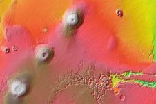
On 2 February 2009, NASA and Google released a new Mars mode in the new Google Earth 5.0 that brings to everyone's desktop a high-resolution, three-dimensional view of the Red...
Virtual Geomatics (TX, USA) and Sanborn have agreed to procure Virtual Geomatics VG4D software solutions for Sanborn\'s LiDAR operations. The Virtual Geomatics\' software solutions will initially be deployed for production...
This site uses cookies. By continuing to use this website, you agree to our Cookies Policy. Agree