Please Look Down!
The US space agency NASA has successfully pushed the asteroid Dimorphos out of its original orbit in the universe, according to a recent announcement. The space rock was hit 11 million kilometres from...
An extensive archive of all articles published on GIM International
The US space agency NASA has successfully pushed the asteroid Dimorphos out of its original orbit in the universe, according to a recent announcement. The space rock was hit 11 million kilometres from...

In this exclusive interview, Nadine Alameh, CEO of OGC, reflects on three decades of GIS software and the importance of interoperability so that geoinformation can be used for the good of society. By ...
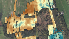
Which challenges were associated with deriving a digital twin to support constructional changes at a 100,000m² health clinic in Germany, and how were they overcome? Renovating existing buildings rema...
The International Organization for Migration is a heavy user of GIS data. Accessible, reliable and timely geospatial data is indispensable in its work in today’s fast-changing world, in which more t...

In which direction is the geospatial industry heading? Which core activities will companies focus on? How will the rapidly progressing technological advances shape the future? The recent edition of Hx...
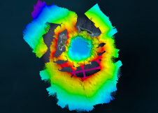
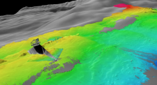
The Tonga Eruption Seabed Mapping Project (TESMaP) is a collaborative mission to discover the undersea impacts of the January 2022 eruption of the Hunga-Tonga Hunga-Ha’apai volcano. Using their coll...
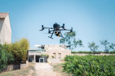
The Earth sciences sector is rapidly adopting UAVs. These two studies have explored combining a gamma-ray spectrometer with a drone to map soil properties. In the Earth sciences sector, sensors for me...

The twelfth session of the United Nations Committee of Experts on Global Geospatial Information Management (UN-GGIM) was held from 1-5 August 2022 at the United Nations headquarters in New York, USA. ...
A project in Aotearoa/New Zealand is combining the use of high-quality DEMs from satellite photogrammetric mapping (SPM) with Lidar technologies to model hazards such as snow avalanches. The resulting...

Local indigenous youngsters in northern Colombia have mapped the boundaries and sacred sites of their village, Gunmaku in the Sierra Nevada of Santa Marta, and the indigenous authorities are happy wit...

When it comes to utilizing the true potential of digital twin technology, Singapore is miles ahead of most other governments. Even those that have already embraced the concept of the digital twin have...

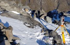
Mount Elbrus, with its peak of 5,642m, is the highest mountain in Europe. This makes it a remarkable attraction for adventurers, hikers and skiers from around the world, which calls for safe and perma...
Attendees of YellowScan's recent Lidar for Drone 2022 Conference headed home with a backpack full of inspiration, according to Wim van Wegen. A relaxed vibe, sunny weather with summer temperatures, sm...

Despite the current conflict, the topographic and cadastral land-register services of the Ukrainian StateGeoCadastre are still operational, certainly in the regions where the country is not under atta...
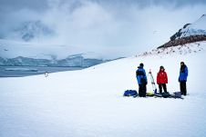
Capturing and measuring the environment in the Arctic and Antarctic is a particularly challenging job. The area of interest is often covered by a thick blanket of snow and ice, while extreme temperatu...
This site uses cookies. By continuing to use this website, you agree to our Cookies Policy. Agree