AI-powered climate resilience
The future of coastal analysis, stormwater mapping and green infrastructure planning
The use of AI in monitoring and modelling climate conditions is bringing about a revolution, especially in the field of geospatial data collection and mapping. With the help of AI-powered digitization, it has become easier to accurately represent real-world changes, enabling communities to better understand critical climate issues like coastal analysis, stormwater mapping and green infrastructure planning. While this level of detail was previously challenging for local communities, it is now possible for governments, commercial organizations and non-profits to develop and maintain a reliable source of truth for geospatial data, which can be used to combat climate change more effectively.
Artificial intelligence (AI) is revolutionizing how communities understand critical climate issues related to coastal analysis, stormwater mapping, green infrastructure planning and more. It’s no secret that geospatial data and mapping are powerful tools for understanding climate change and building resilience strategies. For decades, geographers have mapped areas at risk – not only in order to share information with the public, but also to model and predict future climate events.
Digitizing a changing climate
Geospatial data collection and curation has come a long way over the years, and AI will continue to play an increasingly important role in this evolution. Thanks to AI-powered mapping, the millions of images captured each day by satellites, aeroplanes, uncrewed aerial vehicles (UAVs or ‘drones’) and even street-view cars are now being efficiently and accurately digitized into actionable map features. This AI-based data is changing the way climate scientists map, track and analyse critical elements of the environment, such as rising sea levels, coastal erosion, stormwater infrastructure, green space and urban heat islands.
Before the recent advancements in AI, achieving this level of detail and accuracy was time-consuming, expensive and difficult for local communities trying to maintain their own land cover database. Traditionally, these maps and classifications were created by geospatial teams manually digitizing each feature in their imagery and adding relevant attribution, then doing it all over again once updated imagery became available. While this was feasible to produce generalized maps of climate conditions across large areas, it was insufficient for communities looking to boost their climate resilience by analysing their area in granular detail.
Nowadays, however, features that previously took years to manually digitize can now be extracted from imagery in just weeks using AI-based mapping systems. By helping organizations to digitize geospatial imagery efficiently, at scale and cost-effectively, such solutions enable governments and organizations to develop and maintain a source of truth for geospatial data that can be used to predict and mitigate climate change.
AI-powered coastal analysis
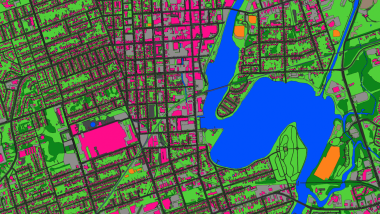
Coastal communities with a heavy reliance on the marine economy are especially vulnerable to the effects of climate change. In addition to sea level rise and its associated risks to property and infrastructure, wildlife habitats and marine ecosystems are increasingly affected by climate change and urban sprawl. To help US coastal communities build resilience, the National Oceanic and Atmospheric Administration (NOAA) is using AI-powered geospatial data. With accurate, comprehensive and up-to-date land cover and land use data, coastal communities across the USA are able to identify populations, property and infrastructure that are vulnerable to climate events. They can also monitor and predict wildlife habitat loss due to climate change, and analyse its effects on the marine economy, which was responsible for about US$361 billion of the USA’s gross domestic product (GDP) in 2020.
Before leveraging AI-based mapping to extract features for its land cover dataset, NOAA relied on 30m-resolution satellite imagery, providing public updates every five years. While this data proved incredibly useful in sharing climate change information with millions of people worldwide, it left coastal communities who faced frequent climate events looking for a more detailed and up-to-date solution. To enable coastal areas with more detailed land cover and land use data, NOAA is now providing 1m resolution data derived from aerial imagery using Ecopia’s AI-based systems. The increased resolution of the imagery means that communities now have the granularity of data they need for local mapping and modelling, and the AI-powered feature extraction leads to faster updates to accurately reflect changes in the real world.
This up-to-date, reliable land cover data is empowering coastal communities throughout the USA to understand flood risk, stormwater infrastructure, urban heat islands, tree equity and more critical elements of climate resilience. But without the efficiency provided by AI, this transition would not have been feasible, as manual digitization that maintains GIS-professional accuracy is typically expensive and time-consuming.

Enhanced stormwater mapping and flood modelling
Coastal communities are not the only areas leveraging these advancements in data and mapping to develop climate resilience. As climate change leads to increased stormwater events and overwhelmed infrastructure, even inland communities are turning to geospatial technology and AI in their mitigation and resilience efforts. AI is revolutionizing how municipalities map and classify impervious surfaces to model stormwater’s effect on an area. With accurate map features that detail the type of material of each surface, as well as those around it, engineers can better determine appropriate runoff coefficients for flood modelling. AI’s ability to regularly extract features with such granular detail means communities can maintain an up-to-date database of infrastructure to better predict and mitigate damage from stormwater events.
The Canadian community of Peterborough, Ontario is leveraging this AI-driven approach in its stormwater planning to enhance their flood models amidst a rapidly changing climate. Until AI-based feature digitization was introduced, Peterborough relied on a mix of 1D and 2D datasets of varying vintages and quality, making it difficult to accurately predict and prepare the community for stormwater events. Now, based on the extraction of both impervious surface and natural feature data supported by AI, Peterborough’s hydrologists have developed a 2D surface mesh representing land cover, providing critical information related to water depth, velocity and surface roughness throughout the area. Peterborough now has a reliable database of land cover and highly detailed flood models to enhance its climate resilience.
In the USA, AI-based mapping technology is helping municipal governments design and fund stormwater infrastructure improvements that will similarly boost climate resilience. The City of Los Angeles, for example, is leveraging Ecopia’s data to repurpose traffic medians for water conveyance and infiltration by incorporating vegetating and stormwater infrastructure. Meanwhile, in Detroit, impervious surface data digitized by AI is being used to calculate equitable stormwater utility fees for each property, in turn funding the municipal government’s infrastructure and climate-resilience improvement projects.

Achieving net zero with AI-driven green infrastructure planning
While coastal analysis and stormwater mapping is critical for developing climate resilience strategies, it is equally important to leverage AI to optimize green infrastructure as a climate change mitigation tactic. As many nations, communities and organizations work to achieve net zero by 2050, having up-to-date, detailed and accurate maps of both the manmade and natural environments is changing the way society understands carbon neutrality.
Producing land cover data that represents the real world is one way AI is transforming green infrastructure planning. Through the creation and maintenance of comprehensive land use maps, governments and other organizations are understanding how land cover is distributed across an area and what that means for its climate resilience. Mapping impervious surfaces is a component of this, but to really analyse a community’s resilience to a changing climate, all land use must be accounted for.
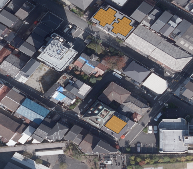
To help calculate progress toward net zero, many communities are leveraging AI-based mapping data to compare the amount of green space to paved surfaces, provide insight into the urban heat island effect, and map all green roofs or solar panels in an area. The level of detail AI is able to extract from geospatial imagery is critical, as many of these features are small and easily missed by other mapping solutions.
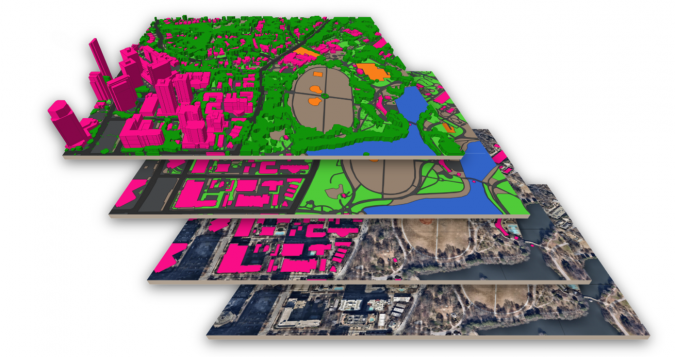
To support the Canadian government’s commitment to reach net zero by 2050, Sustainable Development Technology Canada (SDTC) funded a recent project to map Canada’s hundred largest cities (by population) in 3D using AI-based technology, providing communities with insight into land use that can be used to inform climate resilience strategies. The data is curated so that each layer is a different classification, enabling analysis of not only a bridge, but also the green space or the river that runs under it, for instance. The data is currently in production; once completed, each city will receive complimentary access to assist in their net zero targets.
SDTC has also funded similar digitization projects in other areas of the world to promote carbon neutrality. For example, humanitarian organizations in Sub-Saharan Africa are currently leveraging Ecopia’s AI-powered maps to optimize routes between field sites, reducing wasteful carbon emissions that contribute to climate change.
Conclusion
Building climate resilience is complex and evolving, but AI is giving communities the tools they need to predict, mitigate and combat disastrous climate events. AI-based maps are providing an unprecedented level of detail and freshness for climate scientists, government officials and business strategists alike to use as they model and analyse rapidly changing climate conditions and plan the creation of green infrastructure.
Further reading
https://coast.noaa.gov/digitalcoast

Value staying current with geomatics?
Stay on the map with our expertly curated newsletters.
We provide educational insights, industry updates, and inspiring stories to help you learn, grow, and reach your full potential in your field. Don't miss out - subscribe today and ensure you're always informed, educated, and inspired.
Choose your newsletter(s)


