Creative Traps in Maps
Maps undoubtedly play an important role in society. From use in daily life to professional applications, maps help us navigate, plan activities and gain insight into our surrounding environment. Although we know that all maps have a certain accuracy, we rarely question the existence of streets and places we find on a map.
Throughout time, however, various cartographers have used our good faith in maps to protect their work from being stolen. Their creative ways to trap copyright violators has led to a variety of map ‘mistakes’, some of which have survived for years before being discovered. This article presents some of the strangest copyright traps to date.
Known typically as ‘trap streets’, map makers have been deliberately adding minor errors to maps for ages. A fake street, dead end, additional river bend or altered mountain summit altitude; all are examples of Easter eggs that can prove the origin of a map in case of suspected copyright infringement. These trap streets are usually subtle, innocent alterations that do not interfere with navigation and generally go unnoticed. However, some map makers seem to have pushed the boundaries of cartographic freedom and have created entire villages that do not exist.
Turning Fiction into Reality
One of the strangest examples of a phantom settlement probably is Agloe, ‘located’ roughly 200 kilometres northwest of New York City. The settlement was added to the map sometime in the 1920s or 1930s by Otto G. Lindberg and Ernest Alpers of the General Drafting Company (GDC). The name of the town – which was nothing more than an intersection of two gravel roads – is the anagram of their initials and was meant to catch an unsuspecting copier red-handed. A couple of years after Agloe was made up it appeared on another map, of Rand McNally, one of GDC’s competitors. GDC believed to have a strong case against Rand McNally for violation of copyright. What they did not know, however, is that a real Agloe had been founded in the meantime: a store was now located in the phantom settlement, the Agloe General Store. The store had taken its name from a map of one of GDC’s clients, so Rand McNally could prove Agloe actually existed. An illustrative example of fiction turned into reality.
Argleton
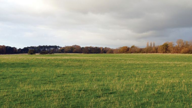
Another famous example is Argleton, located in Lancashire, UK. The settlement Argleton appeared on Google Maps and Google Earth for years, but is nothing more than an empty meadow in reality. Since Google’s services are used by many other information services, Argleton was also included in various real-world listings, ranging from weather services to real estate agencies. After the phantom settlement was discovered in the autumn of 2008 it gained a lot of media attention in the years to follow; funny websites were launched and companies even started selling merchandise related to Argleton. Many people believe Argleton to be a trap street, but some think it was just an error. Map makers often deny the fact that they alter maps to prevent them from being copied. But whether or not Argleton was a mistake, it definitely got more attention than the average meadow out there.
Personal Involvement
Settlements and various other landmarks have been made up in the past – and not only for the sake of copyright protection. In the 1970s a map of Boulder County (Colorado) showed a non-existing summit known as ‘Mount Richard’ for a few years, although it is doubted whether this imaginary peak was meant as a real copyright trap. Some believe it was just a simple joke of the drafter, whose first name was also Richard. Another example of two phantom settlements that were put on the map as a personal statement are Beatosu and Goblu in Ohio, which were two fake towns put on a map of Michigan in the 1970s by Peter Fletcher, an alumnus of the University of Michigan. The names of those towns were inspired by the slogan of the University of Michigan (‘Go Blue’) and their rivals from the Ohio State University (‘Beat OSU’).
Ski Slope
Most trap streets are far more subtle than complete phantom settlements, and it is assumed many are still out there. London, for example, once had streets like Moat Lane on Google Maps, which do not exist in reality and have now disappeared from the map again. The London A-Z indicates there is an imaginary ski slope in the middle of Haggerston Park – and some claim this street atlas contains at least 100 trap streets although that number is difficult to confirm. Small lanes and dead ends are less likely to be discovered as trap streets than entire villages that are made up, which is why there are probably many more Easter eggs than we currently know.
Real Mistakes?
Strange street names or phantom settlements are not always put on a map on purpose. So-called ‘paper streets’, for example, are streets that are planned by city planners and included in blueprints, but not built eventually. Misspellings can find their way onto maps as well, and there are many other data errors that can become visible on a map. Since trap streets usually are only minor ‘errors’, it is not always clear whether a map error is an innocent mistake, or a real copyright trap. In addition, trap streets vanish from maps quickly after they are discovered, especially in the digital era with many online map suppliers that can be used to cross-validate such findings. Nevertheless, it goes without saying one should always be aware that maps reflect the real world only to a certain degree – there is always a chance to come across some artistic input of a cartographer.
This article was published in GIS Professional June 2017

Value staying current with geomatics?
Stay on the map with our expertly curated newsletters.
We provide educational insights, industry updates, and inspiring stories to help you learn, grow, and reach your full potential in your field. Don't miss out - subscribe today and ensure you're always informed, educated, and inspired.
Choose your newsletter(s)


