
Geospatial digital twins will make cities smarter
Building tomorrow’s cities today
Thanks to the ability of digital twins to provide insights into the reality of present conditions and the impacts of future scenarios, they have the potential to revolutionize the planning and efficiency of urban environments. How? This article presents four scenarios demonstrating ways in which geospatial digital twins will make tomorrow’s cities smarter.
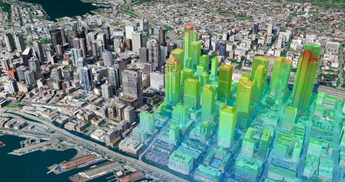
From the evening news to real estate marketing, 3D virtual environments seem to be everywhere. People are now accustomed to ‘flying’ around any part of the world without leaving their armchair, or ‘walking’ from room to room in an architect’s concept of a yet-to-be-built home. These 3D virtual scenes, often called digital twins, provide planners with insights into the reality of present conditions and the impacts of future scenarios. Their ability to do this now has the potential to revolutionize the planning and efficiency of urban environments, from modelling new construction plans to managing traffic flows and noise pollution.
It is estimated that the market for digital twin technologies will reach US$73.5 billion by 2027, according to recent research by McKinsey. In most cases, these digital twins are made possible by integrating sensor technology and artificial intelligence (AI) technology. Airborne sensors quickly and cost-effectively collect accurate imagery and elevation data as core components of generating 3D environments. AI and machine learning algorithms can extract a variety of feature information to transform these geospatial datasets into immersive digital twins ready for visualization, modelling and simulation.
Constant feedback loop
One of the many recent developments is that a digital twin can be kept up to date with real-time data inputs within a constant feedback loop, capable of empowering action and decision-making. This innovation allows planners to understand the current state of physical environments, such as cities, at a greater depth than ever before, discover potential challenges and model ways to be more efficient.
Digital twins are deployed to analyse and determine how changes can make urban areas more liveable, navigable and sustainable. The increasing affordability and accessibility of sensors for collecting 3D geospatial data likewise facilitates the democratization of digital twin technology. Not only can cities now afford them, but the datasets – as well as the modelling and simulation packages that leverage the 3D data – can also be obtained and utilized productively by the private sector for commercial purposes.
There are many advantages of using digital twins, but the most beneficial are undoubtedly those that involve modelling and simulating the future to discover the impacts of proposed changes to current conditions. Using hybrid airborne systems like the Leica CityMapper-2, which combines optical imaging and Lidar sensors for simultaneous image co-registration and data capture, it is now possible to generate digital twins with unprecedented accuracy.
Below are four scenarios demonstrating how digital twins will transform urban environments in the near future.
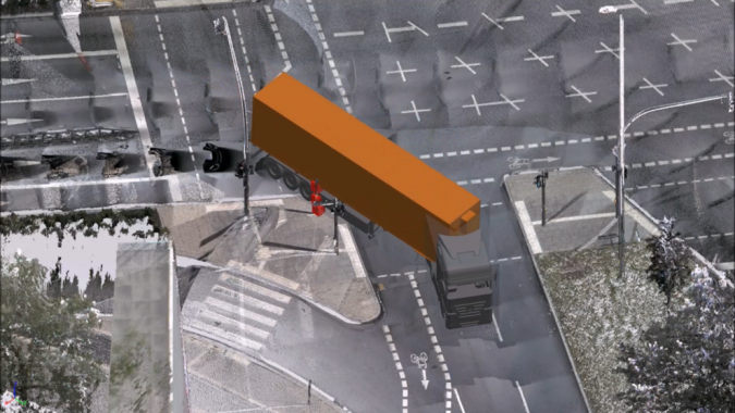
1. Vehicle clearance detection
As cities grow more crowded, managing traffic congestion becomes critical for mobility and commerce. By creating highly detailed virtual replicas of urban areas, planners can visualize the domino effects of disruptions: people are late for work, appointments are missed and product deliveries are delayed. For example, digital twins can model new truck-loading zones outside a busy shopping complex. Combined with real-time traffic data and AI, planners simulate patterns with the new zone in place to find potential choke points from large vehicles entering and exiting. Traffic engineers can use this live information to designate alternate routes for large commercial vehicles, reducing disruption.
Digital twins also enable the testing of dynamic solutions such as smart traffic signals. Traffic patterns are simulated under different signal-timing scenarios for the most optimal timing, maximizing flow at various times of day and during special events or holidays. During infrastructure projects, the impact of lane closures and detours is tested in the virtual city, and traffic departments prepare contingency plans knowing the exact effects of diversions.
Additionally, trucking companies can leverage the same digital twin simulation to train their drivers in advance of navigating the crowded downtowns of specific cities on their delivery routes, saving time and even minimizing vehicle emissions. In these ways, digital twins become a virtual laboratory for traffic planning innovation. Solutions are proven before real-world implementation that once required more costly and disruptive experimentation.
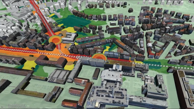
2. Noise pollution mapping
A realistic noise map may be the ultimate example of how digital twins have the potential for high-impact decision-making. In this simulation, the noise from an existing city tram has been modelled and represented as a volume bubble. Each layer of the bubble portrays loudness in decibels. As the tram moves through the city, so too does the noise bubble, showing precisely where and how much each volume level affects residential buildings, offices and restaurants.
Potential renters or homebuyers can use this information in advance to determine if their new home will be uncomfortably loud each time a tram passes by. For a tram line in the planning stages, city transport planners could use the same simulation to identify the best routes to reduce noise impact, or to plan for noise abatement walls to shield homes, hospitals and schools from ongoing noise pollution.
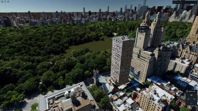
3. Skyscraper construction planning
As urban centres experience rapid growth, high-rise tower blocks are proliferating in areas with limited available land for new construction. In one real-world example, the developer of a proposed high-rise building leveraged a digital twin to showcase the project to potential investors. The digital twin modelled how the planned tower would appear within the existing cityscape. By simulating the building at various heights, the developer demonstrated how additional stories and units would affect the living experience and potentially maximize revenue with penthouse-level rental rates and sales prices.
This model also enables extensive analysis by city zoning officials. By visualizing the planned tower in the context of neighbouring structures, planners can determine potential impacts on sightlines from existing buildings that could warrant height restrictions as well as effects on parking space and congestion. The city planning department could also simulate the tower’s solar reflection to assess increased heat sink impacts or measure the magnitude of new shadows cast over public parks.
With virtual models, the digital twin reduces speculation and helps assess the trade-offs associated with new developments. In this specific example, the digital twin ultimately provided a comprehensive means for all stakeholders to quantify the proposed project’s effects before final approval. As this technology matures and becomes more commonplace, urban planning decisions and negotiations promise to become more informed, improving sustainability and efficiency.
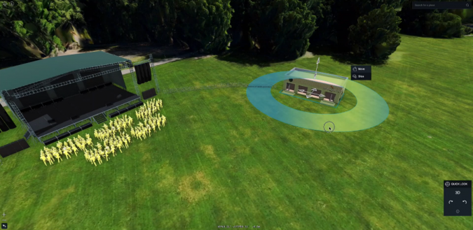
4. Event planning
Event planners can create stunningly detailed and accurate virtual models of venues with digital twins. Various stage placements and orientations are visualized to refine layouts and ticket sales plans for maximum attendance and revenue. Key factors can be modelled, such as sightlines and viewing angles to identify ideal seating areas with unobstructed views, and acoustics and lighting to refine the audience experience through optimized sound and lighting strategies.
Most importantly, public safety officials can test mapped exit routes to determine ideal emergency evacuation plans. Crowd movement and flows are simulated to identify potential bottlenecks, informing the placement of vendor booths and amenities to minimize congestion. Digital twins even assist in programming complex pyrotechnics or drone shows by evaluating firing lines, flight paths and no-fly zones to avoid obstructions. Precise mapping of streets, alleyways and walkways also supports plans for getting emergency vehicles in and attendees out as quickly as possible, if necessary.
With this ability to eliminate guesswork through information-rich simulation, digital twins enable events to be meticulously engineered, planned and optimized. Planners can drive revenue using data-driven insights that are simply not possible from traditional static planning diagrams or models.
Digital twins are the future of urban environments
The HxGN Content Program supports initiatives like these with its Metro HD data offering, including 3D mesh models of major cities. Captured with the Leica CityMapper-2, providing simultaneously co-registered imaging and Lidar data, the 3D mesh models generate highly accurate and detailed digital twins that make simulations like those described above a reality. By leveraging the potential of digital twins, planners can improve the safety, efficiency and habitability of urban centres around the world.

Value staying current with geomatics?
Stay on the map with our expertly curated newsletters.
We provide educational insights, industry updates, and inspiring stories to help you learn, grow, and reach your full potential in your field. Don't miss out - subscribe today and ensure you're always informed, educated, and inspired.
Choose your newsletter(s)


