
Is it possible to create a cadastral map of Europe?
Hope and optimism for openness and availability
Over the past 20 years, various initiatives have been launched reflecting the importance of cadastral data for land management and spatial development. But how have these initiatives enhanced the possibility to build a cadastral map of Europe in terms of promoting the harmonization, integration and interoperability of spatial data across Member States?
Cadastral data is one of various geospatial datasets of key importance for land management and spatial development. Cadastral maps with accompanying land-related attributes have become fundamental for many application fields, such as spatial planning and development, protecting state lands, securing of land tenure, real estate market analysis, facilitating land reforms, land consolidation, administering agricultural subsidies through the Land Parcel Identification System (LPIS), forestry, soil protection and environmental measures. They underpin land governance, property rights, economic activities, infrastructure development and sustainable resource management, contributing to social stability, economic prosperity and environmental sustainability.
So is it possible to create a digital cadastral map of Europe to trigger long-term socio-economic benefits by facilitating data integration, exchange and analysis across borders? Ideally, the map should be simple to use desktop GIS or online GIS software to find, access, download and combine data about Europe’s cadastral parcels. But this would require common standards and formats to achieve interoperability between the various national data sources. In this context, several initiatives regarding cadastral and other geospatial data have been launched in the last 20 years. At the European level, it started with the Permanent Committee on Cadastre in the European Union, the European Land Information Service (ELIS), INSPIRE, UN-GGIM Europe with the FELA and recent European policies on open data and high-value datasets.
In order to serve its purpose and assure transparency in land administration systems (LAS), cadastral data – including cadastral maps – should be open and publicly available to all. In many jurisdictions, the land cadastre has remained the key LAS component, with georeferenced cadastral maps and land-related attributes organized within land information systems (LIS) becoming an integral part of national spatial data infrastructures (NSDIs).
Strong demand for a European cadastral map
The data related to the cadastral parcels can be widely used in various phases of policymaking. By enabling the link with the parcel owner, it is possible to know if the land is public or private; this is key information for decision-makers who may take different means of action according to the land ownership status. It also makes it enables governments to manage their public land (e.g. by acquiring new parcels for a project), to organize land consolidation, to improve conditions for agriculture, to target owners with specific communication (e.g. to encourage them to better isolate their buildings in order to save energy or to reduce vulnerability to risks), to check if a permit claimant is the parcel owner, or to find the owner of a polluting parcel.
There is a clear, strong demand for the creation of pan-European datasets including a European cadastral map. The main user here is the European Commission (EC) itself, especially DG JUST, DG AGRI and DG ESTAT regarding the cadastral data. Until a few years ago, the requirements of the EC and EU agencies for geospatial information were limited in terms of scope and scale. In most cases, they were met by the products delivered by EuroGeographics. However, in recent years, use cases and consequently demand have evolved. This requires integrating and processing different types of geospatial data with a wider scope, higher spatial quality and better spatiotemporal resolution. The number of spatial analyses has increased and spatial analytics is now common practice in many services of the EC. Spatial information derived from spatial data supports policymaking in various application domains such as environment, statistics, agriculture, transport and energy, or other EU community data programmes such as Copernicus.
The cadastral parcel data also helps in understanding the spatial development patterns and land use characteristics. In the EC Common Agriculture Policy (CAP) context, it is quite common for cadastral data to be used to define the eligible area for subsidies. Furthermore, a background cadastral map is necessary for land use planning and land management measures, where rights, restrictions and responsibilities can be displayed on maps, thus making everyone aware of the restrictions and responsibilities that apply on a property. In addition, the adoption of the UN 2030 Agenda for Sustainable Development and of the related indicator framework for monitoring the realization of the Sustainable Development Goals (SDGs) requires various types of data, including geospatial and land-related data. There are, of course, many other users of cadastral data.
The role of INSPIRE
Looking at the current EU cadastral data landscape, there are many initiatives aiming to provide open cadastral data in Europe and the possibility to share and use them in an interoperable way: PCC, EULIS, INSPIRE, EuroGeographics Open Cadastral Map, and UN-GGIM: Europe. INSPIRE is regarded as the most reliable source of information since it is a legally driven initiative and as such obligatory in the EU Member States.
The legal framework of INSPIRE has been set by the Directive (2007/2/EC) and interdependent legal acts, which are called ‘implementing rules’, in the form of Commission regulations and decisions. The cadastral parcels data theme is included in Annex I of the INSPIRE Directive, which means that it is considered as reference data, i.e. data that constitutes the spatial frame for linking and/or pointing at other information belonging to a specific thematic field such as environment, soil, land use and many others. As much as possible, in the INSPIRE context, cadastral parcels should be forming a partition of national territory. A cadastral parcel should be considered as a single area of the Earth’s surface (land and/or water), under homogeneous property rights and unique ownership, property rights and ownership being defined by national law (adapted from UN ECE 2004 and WG-CPI, 2006).
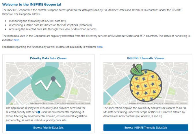
The entry point to the INSPIRE infrastructure is the INSPIRE Geoportal (Figure 1). It serves as a central access point to the data and services from public organizations in the EU Member States and EFTA countries which fall under the scope of INSPIRE. Geoportal offers a range of data formats and may include INSPIRE-conformant and non-conformant datasets. It is possible to search cadastral parcel data based on country, theme or other criteria, and access relevant metadata and download links. The INSPIRE Geoportal enables cross-border data discovery, access, visualization and download.
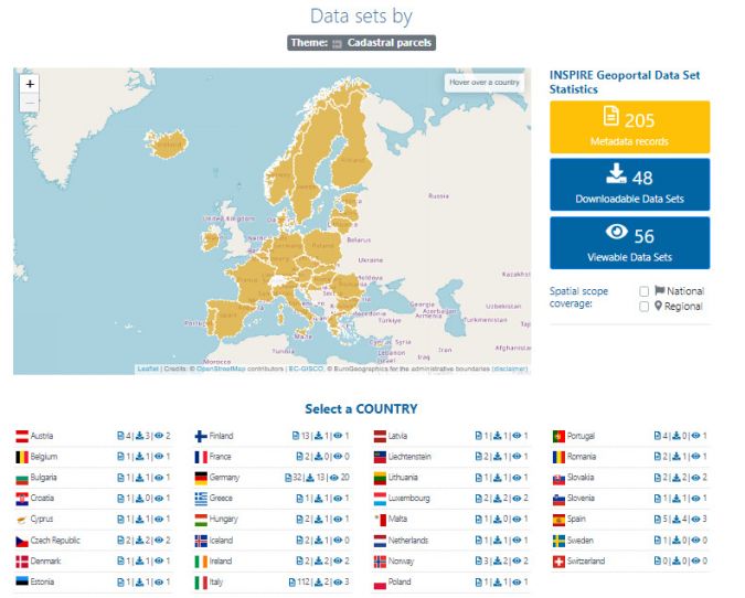
To assess the availability (aimed at the existence of metadata describing spatial data) and accessibility (aimed at the existence of related services for spatial data viewing and downloading) of cadastral data, the authors followed the quantitative indicators used in INSPIRE monitoring and reporting. These values refer to the ability to find (metadata), access, view and/or download data directly from the INSPIRE Geoportal.
Figure 2 shows the total numbers of metadata records (205), downloadable datasets (48) and viewable datasets (56) found for the cadastral data theme on 2 November 2023. An overview for each Member State and EFTA country is provided at the bottom. Clicking on a particular country provided a more detailed overview for that specific country (see Figure 3 for metadata for the cadastral data in Croatia).

Supporting cadastral unification
It is clear that the situation still differs from country to country. The INSPIRE initiative has played a significant role in supporting the cadastral unification at the European level by promoting the harmonization, integration and interoperability of spatial data across Member States. While INSPIRE does not specifically focus on cadastral data, its principles and framework have facilitated the exchange and sharing of cadastral information among European countries taking their first steps toward today’s efficient provision of high-value datasets.
But while INSPIRE provides a framework for harmonizing and sharing spatial data, including cadastral data, the cadastral unification at the European level also relies on the willingness and efforts of individual countries to align their cadastral systems, policies, and practices. National cadastral agencies and governments play a crucial role in implementing the necessary reforms and initiatives to support the unification process.
Conclusion
There are many initiatives that aim to provide easy and simple access to cadastral data, because cadastral data is necessary – and often irreplaceable – in so many use cases. The importance of a cadastre lies in its ability to provide accurate, up-to-date and accessible information about land parcels, property boundaries, land ownership and related attributes. They underpin land governance, property rights, economic activities, infrastructure development, and sustainable resource management, contributing to social stability, economic prosperity, and environmental sustainability. Therefore, there is a strong need for a digital European cadastral map. INSPIRE has made significant contributions to the harmonization and sharing of spatial data, including cadastral information. The authors have assessed the availability and accessibility of cadastral data in the EU and EFTA countries using the INSPIRE Geoportal. The results of their analysis show that there is still work to be done. Despite INSPIRE and other initiatives, it seems that it is not yet currently possible to quickly and simply create a cadastral map of Europe.
However, recognition of cadastral data as a core dataset by UN-GGIM: Europe and as a high-value dataset in recent European policies awakens hope and optimism that the cadastral data will become open and available in years to come. If all countries implement INSPIRE according to its requirements together with the guiding principles of findability, accessibility, interoperability and reusability (FAIR), it would be fairly straightforward to produce the necessary Europe-wide geospatial datasets including cadastral ones. This would ultimately enable the possibility to build a cadastral map of Europe.

Acknowledgments
This research is supported by the scientific project UNIN-TEH-23-1-11 Digital Twins and Smart Cities from the University North, Croatia.
Further reading
Cetl, V.; Šamanović, S.; Bjelotomić Oršulić, O.; Lisec, A. Building a Cadastral Map of Europe through INSPIRE and Other Related Initiatives. Land 2023, 12, 1462. https://doi.org/10.3390/land12071462
Kotsev, A.; Minghini, M.; Tomas, R.; Cetl, V.; Lutz, M. From Spatial Data Infrastructures to Data Spaces—A Technological Perspective on the Evolution of European SDIs. ISPRS Int. J. Geo-Inf. 2020, 9, 176. https://doi.org/10.3390/ijgi9030176
Markovinović, D.; Cetl, V.; Šamanović, S.; Bjelotomić Oršulić, O. Availability and Accessibility of Hydrography and Hydrogeology Spatial Data in Europe through INSPIRE. Water 2022, 14, 1499. https://doi.org/10.3390/w14091499
Minghini, M., Cetl, V., Ziemba, L.W., Tomas, R., Francioli, D., Artasensi, D., Epure, E. and Vinci, F., Establishing a New Baseline for Monitoring the Status of EU Spatial Data Infrastructure, EUR 30513 EN, Publications Office of the European Union, Luxembourg, 2020, ISBN 978-92-76-27384-4, https://doi:10.2760/296219, JRC122351.

Value staying current with geomatics?
Stay on the map with our expertly curated newsletters.
We provide educational insights, industry updates, and inspiring stories to help you learn, grow, and reach your full potential in your field. Don't miss out - subscribe today and ensure you're always informed, educated, and inspired.
Choose your newsletter(s)


