Tree Crown Map: revolutionizing tree monitoring in urban areas and beyond
Mapping Poland’s tree population from above
A pioneering project in Poland has proved that aerial mapping, combined with Lidar technology, can be an invaluable tool for accurately mapping the green urban environment. In fact, the new, cost-effective method has been extended to encompass the country’s entire tree population. This article highlights the groundbreaking project by MGGP Aero. The company has achieved remarkable results by using advanced computer algorithms to identify and elegantly reconstruct numerous tree species from hyperspectral images. Additionally, the use of Lidar enabled multiple applications including measuring and visualizing crown height and mapping biomass.
Trees are of crucial significance to life on Earth, so it is important to gather as much information and insights about them as possible. They provide shade and can cool the air by 2 to 8°C, so strategically placed trees can be excellent natural air conditioners in cities. Mature trees can absorb up to 150kg of carbon dioxide per year, and also absorb other polluting gases such as nitrogen dioxide, carbon monoxide, sulphur dioxide and ozone. Moreover, trees remove particulate matter from the air by trapping them in their leaves and bark, leading to cleaner and healthier air in urban areas.
To calculate a diverse tree population’s potential societal benefits – including the impact on health and well-being, climate and biodiversity – and to ensure that the various benefits are fully utilized, it is necessary to have a clear understanding of all the tree-related data. This includes the size of each tree – because the larger the tree is, the greater its effect will be – and also the distribution of trees in a particular area or region. So how can government authorities obtain this valuable ‘green data’ effectively? The answer lies in geospatial data, but gathering it is not without its challenges, especially when the tree population comprises millions of trees.
Need for faster tree monitoring methods
Using conventional approaches such as field inspections, it can take around 15 minutes to collect data about a single tree. Considering that there the Polish capital of Warsaw has more than seven million trees scattered throughout the city, the municipal authority realized that any data gathered and analysed solely using these conventional methods would quickly become outdated. Therefore, there was a strong need for methods that speed up the monitoring process.
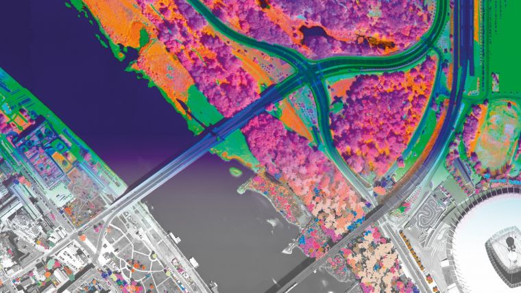
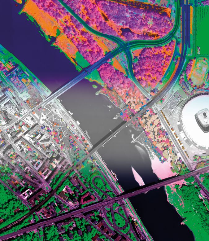
City officials turned to the scientists at MGGP Aero with experience in modern remote sensing technologies. The company suggested conducting surveys remotely, using a combination of remote sensing data, aerial photos (RGB with a resolution of 10cm and hyperspectral imaging) and Lidar, to compile a comprehensive list of all the trees not only in Warsaw, but also in the whole of Poland.
This led to the idea for the ‘Tree Crown Map’. It started with a pilot of an area of 50km2 of Warsaw, carried out in December 2018 by MGGP Aero. The pilot proved to be a success, resulting in a realistic estimate that approximately 25% of the area was covered by tree canopies, with the most common species being Scotch pine, oak and several species of linden. Further analysis revealed the linden to be in the worst condition in Warsaw. The project was continued with great enthusiasm, and the entire city of Warsaw – covering an area of more than 500km2 – had been mapped from above by the end of 2020. The resulting highly advanced map of individual trees recognizes nearly 50 different taxa, including detailed information on the geometry of their canopies and health status. Since 2020, the MGGP Aero team has carried out analogous tree inventories using remote sensing in another four Polish cities: Sopot, Jasło, Złotów and Rzeszów.
Versatile geospatial data toolkit
The Tree Crown Map was created using a diverse range of data sources that were made available through MGGP Aero’s advanced multi-sensor airborne remote sensing platform, designed in-house. This platform allows simultaneous recording of hyperspectral and Lidar data, along with high-resolution RGB and TIR imagery. The platform continually expands to accommodate additional sensors, enabling customized flight campaigns to meet project requirements. Instrument fusion is applied to synergistically combine complementary data types. This approach provides various products derived from the multi-sensor platform, alongside comprehensive analysis facilitated by data fusion techniques. To enhance the accuracy of the model's predictions, the project employed machine learning algorithms based on MGGP Aero's own R&D department's developed methods.
Mapping tree properties
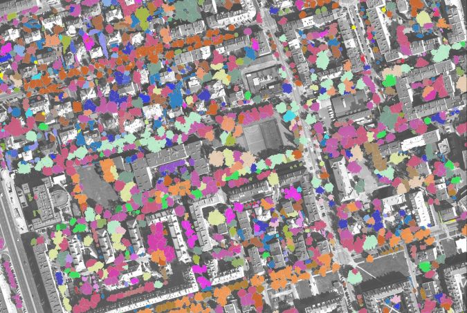
The various data capture technologies and types of geospatial data each brought their own benefits to the project in terms of mapping specific tree properties. For example, thanks to the precise distance measurements between the aircraft and objects on the ground, Lidar results in a highly detailed 3D representation of the urban landscape and enables the identification and characterization of individual trees. Meanwhile, species classification from point clouds is an evolving method that holds significant importance in laser scanning-based forest inventory, ecosystem models and forest management support. This data can play a crucial role in numerous tree monitoring tasks, including the estimation of individual tree height and diameter at breast height.
Additionally, hyperspectral sensors provide significantly more comprehensive information than conventional multispectral sensors, which only measure within three to eight spectral bands. In contrast, hyperspectral sensors record the light reflected from the target across numerous (often more than 200) contiguous spectral bands, covering the visible, near-infrared and mid-infrared regions of the electromagnetic spectrum. Analysis of hyperspectral data enables various objects to be differentiated based on their distinct spectral characteristics, encompassing colour, chemical composition and structure. As trees affected by disease or environmental stress tend to exhibit diminished greenness and reduced foliage, hyperspectral data can be invaluable in evaluating overall tree health based on leaf colour or density.
From capital to country
To effectively harness the remarkable potential unlocked by the initial pilot, MGGP Aero subsequently carried out an extensive survey of the vast array of trees in the whole of Poland. The MGGP Aero specialists leveraged the invaluable release of airborne laser scanning (ALS) data by GUGiK in July 2020, coupled with their extensive expertise in analysing such data, to conduct a comprehensive study employing fully automated methodologies. This groundbreaking study resulted in an intricate aerial depiction of tree distribution throughout the entire nation. Astonishingly, it revealed that the country’s tree inventory encompasses over 3.5 billion crowns, spanning an area of almost 100,000km2 and covering approximately 33% of the total land mass.
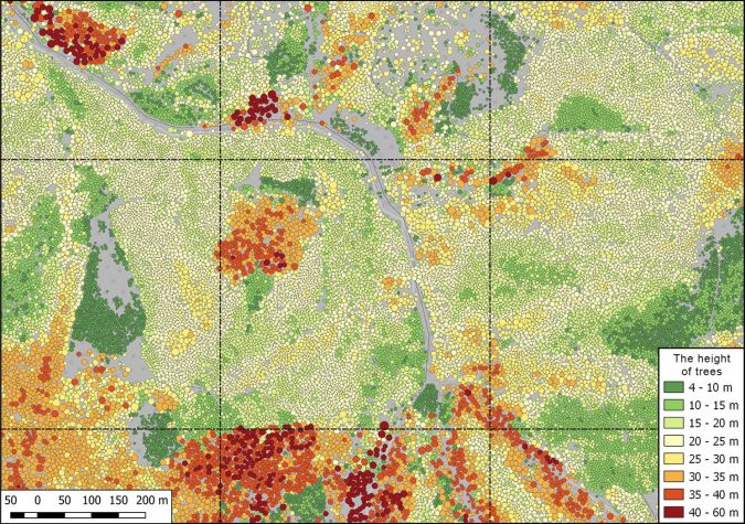
The findings are conveniently presented in the ‘Regional Tree Crown Map’, which showcases the outcomes of the comprehensive tree inventory conducted on a national scale. This product provides an aerial view of the crowns of all trees (excluding those concealed by taller crowns) that satisfy the minimum height requirement of 4m and a minimum crown area of 9m². The Regional Tree Crown Map is accessible to the public through the My Tree Map website, powered by the OBLIVIEW web engine developed by the MGGP Aero team. This web engine can be described as an advanced online platform that combines three separate solutions into one. It provides a comprehensive dataset for applications requiring view analysis and precise building measurements. It is built on geospatial data from six digital sensors, including nadir and oblique imagery views and Lidar.
The data has been released in accordance with the European Union’s INSPIRE directive, which is aimed at creating a common spatial data infrastructure for the purposes of EU environmental policies and/or potentially impactful activities.
Utilizing geospatial tree data
With a range of extensive functionalities, the My Tree Map web application presents trees against the backdrop of aerial orthophotos or OpenStreetMap data. This cartographic representation provides easily understandable information about the location of tree crowns and their height. Furthermore, users can gain free access to additional tree characteristics and information, including tree species, tree health, crown area and volume, tree trunk locations and the diameter at breast height.
Users can browse the data across Poland without limitations, from individual trees to entire cities, at various scales. The website also enables users to purchase the Regional Tree Crown Map for a specific area and download it for use in their own GIS environment. Therefore, the Regional Tree Crown Map represents an essential tool for various authorities, particularly municipalities, and the knowledge derived from it serves as a valuable resource for managing extensive greenery and also adapting to climate change.
Conclusion
Thanks to the innovative geospatial data capture and processing methods in MGGP Aero’s solution, combined with the utilization of a wide range of pre-existing data, comprehensive information about trees in Poland is now easily accessible, thus eliminating the need for specialized knowledge and skills. This user-friendly approach empowers citizens, professionals and policymakers to make use of the tool for a diverse range of activities, including supporting Poland’s initiatives in adapting to climate change. Specifically, the tool holds substantial value for managers overseeing green spaces in local government units, such as municipalities, infrastructure agencies and nature protection services.
Poland’s tallest tree
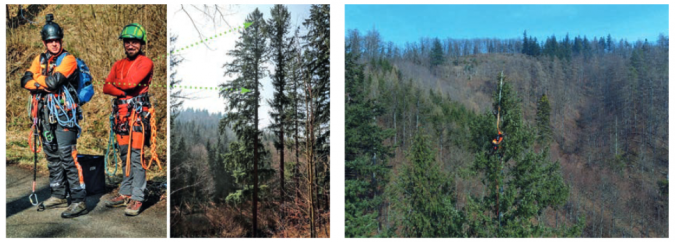
As of September 2020, a Douglas fir with an impressive height of 58.2m standing in the Beskid Żywiecki Mountains was believed to be the tallest tree in Poland. However, following weeks of meticulous analysis of nationwide airborne laser scanning data that had been made accessible by the Head Office of Geodesy and Cartography for the purpose of the Regional Tree Crown Map, Agnieszka Ptak from the MGGP Aero team discovered that some trees in the Sudety Mountains had already exceeded 56 metres in height back in 2011. It was entirely possible that one of them would now be taller than the Douglas fir in Beskid Żywiecki.
In order to definitively confirm this suspicion, field measurements of the tree height were necessary. The initial measurement was conducted by Marcin Kilańczyk, who placed a tape measure at the top of the tallest tree, while Agnieszka Ptak and Dominik Kopeć measured the height against the trunk. The first reading indicated an astonishing height of 59.5m, causing great excitement within the team. To ensure accuracy, Marcin repeated the measurement, resulting in a slightly lower reading of 59.2m. Two subsequent height measurements were then carried out by Bartlomiej Król, with readings at the base of the trunk indicating 59.5m and 59.4m, respectively. Ultimately the team decided to record the tree’s height as the average of these four readings, amounting to 59.4m.
With this significant milestone, the official height record for Poland’s tallest tree now stands at 59.4m. The discovery of this remarkable tree was made possible by the development and utilization of the Regional Tree Crown Map, which harnessed the power of artificial intelligence and airborne Lidar data.
The green city of Wrocław
Many Polish cities are actively pursuing digitalization and adopting modern technologies to manage urban spaces more efficiently, and Wrocław is no exception. The city is working to develop and implement an advanced system called the Urban Greenery Management System and an accompanying e-platform known as Greenery. The primary objective of this system is to enhance the effectiveness of Wrocław’s municipal greenery management activities by providing precise and comprehensive information on the condition of the city’s green spaces.
An interdisciplinary team from MGGP Aero is actively engaged in conducting a thorough inventory of the greenery in specific areas managed by the municipality in Wrocław. The collected inventory data will be vital input for the Urban Greenery Management System. MGGP Aero’s responsibilities include conducting a meticulous examination of trees, marking them with arbotags and identifying the species, varieties, parameters and overall condition. Furthermore, the team are evaluating each tree for further actions and developing recommendations for tree care. In order to accomplish this, they are making extensive use of aerial data and remote sensing techniques for processing and analysis, while conducting on-site measurements for reference purposes. This task involves the active participation of experienced specialists in remote sensing, geoinformation and botany.
One of the notable deliverables as part of this project is the Local Tree Trunk Map, which will provide highly precise information about the precise location of each tree trunk, as well as the breast height and various additional parameters that characterize each tree. Thanks to the Local Tree Trunk Map, MGGP Aero is able to accurately count the number of trees in a specific area with an accuracy rate of 99.9%.


Value staying current with geomatics?
Stay on the map with our expertly curated newsletters.
We provide educational insights, industry updates, and inspiring stories to help you learn, grow, and reach your full potential in your field. Don't miss out - subscribe today and ensure you're always informed, educated, and inspired.
Choose your newsletter(s)


