DeltaQuad and YellowScan team up for Lidar-powered 3D mapping
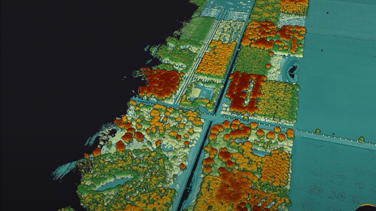
Lidar developer and manufacturer YellowScan and drone manufacturer DeltaQuad have announced a renewed partnership aimed at delivering high-quality 3D mapping data to professionals worldwide. The collaboration involves the integration of the YellowScan Surveyor Ultra Lidar system, which features an embedded camera, into the DeltaQuad Evo drone, offering dense point cloud data covering up to 1,200 hectares.
The YellowScan Surveyor Ultra is a lightweight 360° Lidar system with a 120° field of view, optimized for top-notch mapping and surveying. Distinguished by its high point density and lightweight design, it can now be fully utilized with the DeltaQuad Evo unmanned aerial vehicle (UAV). The Evo is a modern fixed-wing vertical take-off and landing (VTOL) UAV designed for versatile long-range missions.
Multiple payloads
Thanks to its modularity, the Evo can simultaneously carry multiple payloads, including the latest YellowScan Surveyor Ultra with an auxiliary battery, allowing the Evo to achieve flight times of up to 225 minutes and capture up to 100 data points per square metre. This data can be rapidly and efficiently processed using the YellowScan CloudStation software, making the integration ideal for large-scale surveying projects.
Earlier this year, both companies had revealed that the Evo became the first fixed-wing eVTOL UAV to integrate YellowScan Lidar and RGB systems. Tristan Allouis, co-founder and CEO of YellowScan, expressed his excitement about the continued collaboration, stating, "Gradual progress is what empowers trembling innovations. Integrating the YellowScan Surveyor Ultra in DeltaQuad Evo is a small step but opens up the window of opportunities wider for many mapping and surveying experts." Douwe Zeeman, the CEO of DeltaQuad added: "It is a pleasure to see our products help professionals in different industries and regions. Now, enabled to fly longer distances, they can use the benefits of colourized Lidar to the maximum."

Value staying current with geomatics?
Stay on the map with our expertly curated newsletters.
We provide educational insights, industry updates, and inspiring stories to help you learn, grow, and reach your full potential in your field. Don't miss out - subscribe today and ensure you're always informed, educated, and inspired.
Choose your newsletter(s)


