Klau Geomatics introduces Brumby mobile mapping system
Klau Geomatics has introduced the Brumby RTK Lidar system, an innovative mobile mapping solution equipped with powerful Edge Compute capabilities, enabling the generation of highly precise georeferenced point clouds in real time.
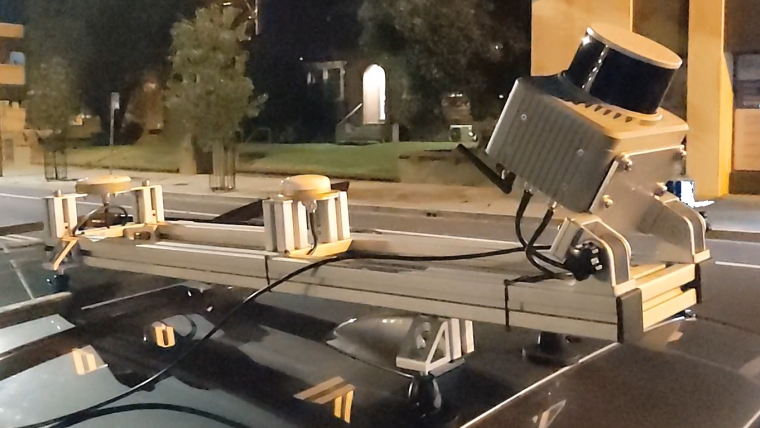
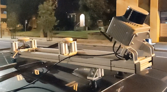
Brumby can be deployed on drones, light aircraft or as a mobile mapping system (MLS). It processes data into a georeferenced point cloud instantly upon capture, eliminating the need for post-processing. This seamless workflow allows for immediate integration into analytics, site assessments, volume measurements and any other required tasks. With Brumby, there's no data backlog – today's capture is ready for immediate use, eliminating delays and streamlining workflows.
The Brumby integrates dual-receiver SPAN INS from NovAtel, running NTRIP RTK or Terrastar-C Pro PPP, with custom code to manage coordinate systems and apply precise geoid models to the trajectory. Then, still in real time, the Lidar raw vectors are projected into millions of accurate RTK survey measurements. The Brumby Edge Compute runs chip-level firmware and highly efficient low-level code on custom hardware to achieve this outstanding outcome.
Real-time change detection
Unlike SLAM systems that generate real-time data, Brumby data is georeferenced, providing real-world coordinates. This distinction is crucial for detecting changes over time. Without precise georeferencing, multiple models exist independently in space. Only when XYZ frameworks align can the impact of time ('T') be analysed. This is vital for assessing ongoing situations, such as identifying persistent road pot holes or monitoring material changes in mining sites. Real-time change detection is especially valuable when addressing current conditions, such as assessing volumes or pinpointing asset locations on military battlegrounds.
Brumbies can be built with Hesai, Ouster, Livox, Velodyne or RIEGL scanners. The current model, with the Hesai XT32M2X scanner, generates clean accurate data at ranges up to 200m (depending on reflectance). This is well suited to mobile laser scanning from a vehicle, or airborne from a drone or helicopter. The price point of the Brumby as an MLS makes land-based scanning a highly efficient option.
“The Lidar industry is currently like surveying was ‘pre-RTK’. For those of you who can remember surveying before RTK (a bit like asking if you remember a world before the internet), you’ll understand where I’m coming from. This is all about to change,” said Rob Klau, director of Klau Geomatics.

Value staying current with geomatics?
Stay on the map with our expertly curated newsletters.
We provide educational insights, industry updates, and inspiring stories to help you learn, grow, and reach your full potential in your field. Don't miss out - subscribe today and ensure you're always informed, educated, and inspired.
Choose your newsletter(s)


