thinkWhere Online Mapper Connects Aberdeen Bypass Project
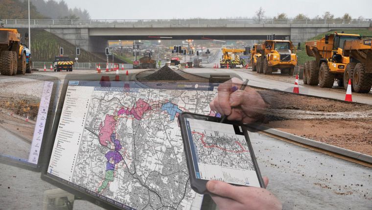
Working alongside the Construction Joint Venture, technology company thinkWhere is helping to improve collaboration and communication on Scotland’s largest road infrastructure project. thinkWhere’s groundMapper software is providing online access to multiple layers of live project maps and geographical data.
Using the web-based viewer, construction workers, managers and stakeholders on the Aberdeen Western Peripheral Route, with Balmedie to Tipperty Extension (AWPR B-T), can instantly access up to date constraint maps saving valuable time and money.
“Due to the extensive area affected by the project and the vast array of datasets available, we needed a solution that would allow us to effectively access, share and communicate geographically referenced information in real time,” commented Angela Gardner, Environmental Manager for the AWPR Construction Joint Venture.
Developed by thinkWhere, groundMapper is an online GIS viewer that brings together location based data. Hosted on a dedicated website, it includes aerial photographs, private water supplies, ecological features, blasting areas, site office locations and more, all overlaid on the basic route layout.
“Using groundMapper, we can instantly access the most up to date constraint data and we have dramatically reduced the need to produce costly and time consuming paper maps, and the associated paper waste,” continued Gardner. “Additional functionality such as the bookmarking tool, annotation and map management functions, combined with its easy online accessibility and integrated base maps, has made groundMapper one the key management tools for this project.”
The AWPR B-T Construction, estimated at £550 million, will see the construction of 54 kilometres of new dual carriageway around the historic city of Aberdeen. The project is predicted to support more than 14,000 jobs in the region and provide £6 billion to the local economy over a 30 year period.

Value staying current with geomatics?
Stay on the map with our expertly curated newsletters.
We provide educational insights, industry updates, and inspiring stories to help you learn, grow, and reach your full potential in your field. Don't miss out - subscribe today and ensure you're always informed, educated, and inspired.
Choose your newsletter(s)


