YellowScan enters hydrography market with bathymetric UAV-Lidar solution
YellowScan, a familiar name in the mapping and land surveying realm, is making a noteworthy entrance in the hydrographic sector with the introduction of its pioneering UAV-based bathymetric Lidar solution. The YellowScan Navigator made its debut at CES 2024, marking a new step for the French company.
Since its inception in 2012, YellowScan has become a household name in the geospatial industry, pioneering innovative Lidar mapping from drones. The company has consistently delivered precise instruments that significantly enhance the day-to-day operations of numerous surveyors. It has earned a reputation for its commitment to developing outstanding products that effectively address the evolving needs of the market.
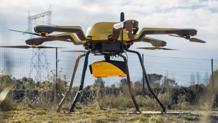
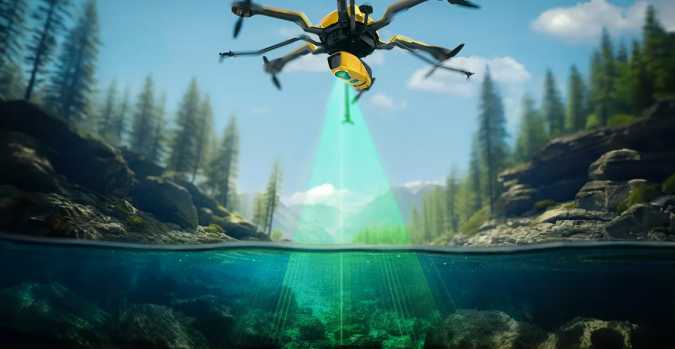
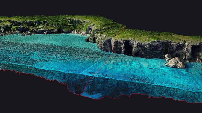
Now taking a significant stride into the hydrographic sector, YellowScan has introduced the YellowScan Navigator. This dedicated solution fulfils the critical need of surveyors to map underwater topography in rivers, ponds and coastal areas. This new venture underscores YellowScan’s continual commitment to innovation and meeting the demands of diverse surveying environments.
Built on proven technology
According to Tristan Allouis, CTO of YellowScan, the YellowScan Navigator addresses an unmet need in the mapping market and supports society in tackling environmental challenges: “As someone who started his career working on bathymetric Lidar data, I’ve always pursued the vision of developing my own system. Mastering hardware design has enabled us to develop advanced processing algorithms and push the system’s performance beyond state-of-the-art.”
The YellowScan Navigator can best be described as a high-end bathymetric Lidar solution designed for drone deployment. This advanced system integrates an in-house-developed laser scanner refined over the past five years and subjected to rigorous testing for optimal performance. The compact design is precisely calibrated to map waterbeds within a depth range of zero to three metres, with the capability to reach depths of 18m in pristine water conditions. Capable of flying up to 100m above the water surface, it provides measurements with exceptional precision and accuracy of 3cm. Additionally, an embedded camera enhances its functionality by providing true-colour data colourization.
YellowScan’s inaugural bathymetric mapper will soon be showcased at Oceanology International 2024, the premier forum where industry, academia and government converge to exchange knowledge and engage with the global hydrographic and ocean technology communities. This event is scheduled from 12–14 March at ExCeL in London, UK.

Value staying current with geomatics?
Stay on the map with our expertly curated newsletters.
We provide educational insights, industry updates, and inspiring stories to help you learn, grow, and reach your full potential in your field. Don't miss out - subscribe today and ensure you're always informed, educated, and inspired.
Choose your newsletter(s)


