Preview: UAV-g 2019
Unmanned aerial vehicles (UAVs or ‘drones’) have become popular instruments for a wide range of emerging applications such as mapping, search & rescue, infrastructure monitoring, precision farming, transport of goods...

Unmanned aerial vehicles (UAVs or ‘drones’) have become popular instruments for a wide range of emerging applications such as mapping, search & rescue, infrastructure monitoring, precision farming, transport of goods...
Calum G. Hoad is a graduate in Geography of the University of Aberdeen.
This issue of GIM International features breathtaking projects. The combination of challenging survey projects, technical innovations and stunning imagery makes it a must-read issue for mapping & surveying enthusiasts. Surveyors often have to carry out projects in harsh or remote environments. While this may not always be optimal for the land surveyors and other geomatics professionals involved, such projects...
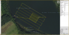
The EvoLogics Multibeam, a new multibeam echosounder option for the Sonobot 5 platform, was released at Ocean Business in Southampton, UK, in April this year. In May, EvoLogics conducted its final trials at one of the company’s regular testing sites the Plessower Lake in Brandenburg, Germany. The company is now taking the Sonobot 5 on a summer demonstration tour for partners and clients so that they can see its efficiency and effectiveness for underwater mapping for themselves. The EvoLogics Multibeam, a new multibeam echosounder option for the Sonobot 5 platform, was released at Ocean Business in Southampton, UK, in April this year. In May, EvoLogics conducted its...

In this Q&A, we asked Trimble’s Jeff Turgeon to share his insights into the current state of the sector and his expectations for the future. Looking at terrestrial laser scanners,...

The Open Geospatial Consortium (OGC) membership seeks to form a new Land Administration Domain Model (LADM) Standards Working Group (SWG). Public comment is sought on its draft Charter. Comments are...
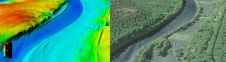
The US Geological Survey (USGS) and Dewberry have jointly released a new topobathymetric Lidar dataset for the Potomac River, extending from the Potomac Highlands in West Virginia to the Chesapeake...
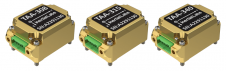
Inertial Labs has unveiled its latest innovation: high-precision three-axis accelerometers (TAA). These compact, self-contained devices mark a significant leap forward in navigation-grade accelerometers, promising unmatched precision in measuring linear accelerations....
PCI Geomatics (Canada) has announced the release and free availability of Geomatica GeoRaster Loader, a desktop product used to load image data and associated metadata into Oracle 10g and 11g....
This site uses cookies. By continuing to use this website, you agree to our Cookies Policy. Agree