Topcon bolsters support for Get Kids into Survey
Topcon Positioning Systems has expanded its support for the Get Kids into Survey (GKiS) project, now serving as the exclusive sponsor of the Global Brand Ambassador Hub. This new platform...

Topcon Positioning Systems has expanded its support for the Get Kids into Survey (GKiS) project, now serving as the exclusive sponsor of the Global Brand Ambassador Hub. This new platform...

Visitor registration is now open for GEO Business, the UK's largest geospatial event. The free-to-attend expo, tailored for geospatial professionals seeking to harness the potential of location intelligence, will return...
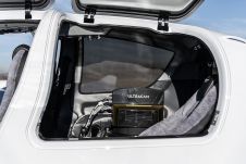
Diamond Aircraft and Vexcel Imaging have announced the next collaboration for a further expansion of Diamond’s special mission aircraft high-end sensor portfolio. The partnership will integrate the UltraCam Dragon 4.1...
Make Underwater Exploration Easier Focus on acoustic sounding technology, Hydro-Tech had developed different products widely applied in underwater exploration industry. Nowadays Hydro-Tech owns completely independent and controllable core technologies in...
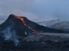
The Icelandic authorities have commissioned Acecore to map the extent and aftermath of the Eldvörp-Svartsengi volcanic system eruption using its high-end drone solutions. Grindavík, a fishing village on the Reykjanes...
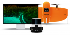
Wingtra has unveiled its innovative Lidar-drone solution. The new Lidar payload is designed to seamlessly integrate the efficiency, ease of operation, and high accuracy of the WingtraOne GEN II drones...
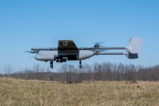
In a new strategic partnership, Inertial Labs' RESEPI Payload Lidar technology will be integrated into E38's advanced E455 drone platform. This collaboration marks a significant milestone in the utilization of...
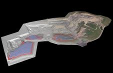
At Geo Week 2024 in Denver, Maptek unveiled its latest innovation: Maptek GeoSpatial Manager. This groundbreaking solution simplifies and streamlines workflows, revolutionizing how mining and civil engineering projects manage data...
Lidar, short for Light Detection and Ranging surveying, represents a sophisticated measuring system leveraging the power of light. Widely recognized for its versatility, Lidar is extensively applied in diverse fields...

Linda Foster oversees Esri’s worldwide strategic vision for land administration and surveying. With 20 years of experience working in the land and resource industry, she is a registered professional land...
This site uses cookies. By continuing to use this website, you agree to our Cookies Policy. Agree