Reappearance of the Danton
In December 2007, the Fugro survey vessel Geo Prospector was performing part of the Detailed Marine Survey for routing the proposed Galsi gas pipeline across the Southern Mediterranean Sea between...
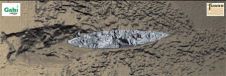
In December 2007, the Fugro survey vessel Geo Prospector was performing part of the Detailed Marine Survey for routing the proposed Galsi gas pipeline across the Southern Mediterranean Sea between...

When surveying the coastline, the integration of bathymetric (below sea level) and laser scanning (above sea level) data causes problems due to the different imaging properties. However, by ensuring that...
DigitalGlobe is to host a webinar, "Deeper Analysis, Faster Insight: Enhanced Applications with WorldView-2's New Spectral Bands," featuring the company's principal scientist, Dr. Kumar Navulur, on Wednesday, 29th July 2009,...

The tenth anniversary International Lidar Mapping Forum (ILMF) took place in Denver, Colorado, USA from 3rd to 5th March 2010, attracting 642 registered professionals from all over the world and...
Ashtech has introduced a new GNSS firmware upgrade for the entire ProFlex line of products, including the ProFlex 500, ProFlex 500 Marine, ProFlex 500 CORS, ProFlex Lite and ProFlex Lite...
The eleventh International Lidar Mapping Forum (ILMF) is accepting abstract submissions for its three-day technical conference. ILMF 2011 is to be held in New Orleans on 7th to 9th February...
DigitalGlobe had received more than 350 entries for the DigitalGlobe 8-Band Research Challenge to date. Submissions have been received from universities, private industry and scientific organisations in over 70 countries...
Intergeo, the world's largest congress and trade-fair for geodesy, geoinformation and land management, will this year be held in Cologne, Germany, from 5th to 7th October. About 15,000 visitors are...
DigitalGlobe has announced the winners of the inaugural 8-Band Research Challenge. The 8-Band Research Challenge encourages researchers to investigate how 8-Band Imagery, available from DigitalGlobe, can enhance analysis and classification...

As part of an ongoing project to bring to city managers, citizens, tourists and others geo-data of the Golden Horn area of Istanbul, Turkey, the authors designed a geo-database accessible...
This site uses cookies. By continuing to use this website, you agree to our Cookies Policy. Agree