Japan launches project to map 90% of coastal waters
The ‘Umi-no-Chizu’ (‘Map of the Sea’) project will use aerial measurement to map 90% of Japan’s shallow coastal waters (to a depth of 20m). This is a joint project by...
The ‘Umi-no-Chizu’ (‘Map of the Sea’) project will use aerial measurement to map 90% of Japan’s shallow coastal waters (to a depth of 20m). This is a joint project by...
The US space agency NASA has successfully pushed the asteroid Dimorphos out of its original orbit in the universe, according to a recent announcement. The space rock was hit 11...
Topodrone, a Swiss-based designer and manufacturer of high-precision Lidar equipment for installation on drones, vehicles and backpacks, has launched Aquamapper, a UAV-based solution for bathymetric surveying and marine construction. The...

Hydrographers are increasingly aware of the added value that a Lidar (Light Detection and Ranging) scanner can bring to bathymetry survey operations. The Teledyne Optech Polaris Laser Scanner, for example,...
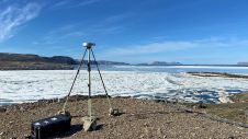
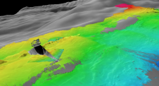
Researchers from the Bureau of Economic Geology have spent the summer in northwestern Greenland conducting research using an airborne Lidar system. The project – Airborne Lidar surveys to quantify Greenland...

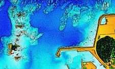
Key stakeholders including the NOAA Office for Coastal Management and NV5 Geospatial created a topobathymetric elevation model of Morro Bay in California as input for environmental conservation. Morro Bay, a shallow...

Leica Geosystems, part of Hexagon, has announced the introduction of Leica Chiroptera-5, the new high-performance airborne bathymetric Lidar sensor for coastal and inland water surveys. This latest mapping technology increases...

These inspiring articles all prove the versatility of the brilliant technology that is Lidar. Sensor miniaturization has made Lidar technology easier to integrate, enabling applications such as UAV-based and handheld...

The aerial survey system for upgrading digital maps of Qatar has become operational. Under the aerial surveys project for Qatar, the mission of aerial photography covering all parts of the...
This site uses cookies. By continuing to use this website, you agree to our Cookies Policy. Agree