3D point cloud aerotriangulation for smart city reconstruction
This study in Malaysia explores the use of sensor-acquired 3D point clouds as the basis for high-quality visualizations for the smart city subsurface. 3D city models are used as the...
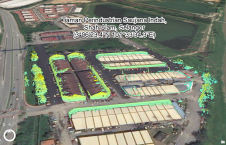
This study in Malaysia explores the use of sensor-acquired 3D point clouds as the basis for high-quality visualizations for the smart city subsurface. 3D city models are used as the...

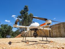
Hi-Target has now developed the new 9-axis IMU RTK V200 to make an even stronger contribution to land survey. In line with the rapid advances in electronics technology and manufacturing capabilities, GNSS receivers for land survey are evolving to be smaller and lighter, with new functionalities. Hi-Target, a leading...
The mission: capturing 21 quarries in 60 days. Squeezed into that timeframe were planning and performing the UAV photogrammetry flights, editing the RAW images, processing the data, extracting the topography using Virtual Surveyor, and production of the orthophotos, Digital Surface Model (DSM), Digital Terrain Model (DTM) and contour maps for each site. The main client, a government institute, needed highly precise and reliable 3D models and maps fast, as well as data their engineers could work with in a CAD environment. “There was a lot of pressure because of the short timeline”, said Nuno Santos, owner and CEO of Aerisurvey, a Mangualde, Portugal-based company specialized in high-precision UAV surveying. Mapping 21 Quarries in 60 Days The mission was to capture 21 quarries in 60 days. Squeezed into that timeframe were planning and performing the UAV photogrammetry flights, editing the...
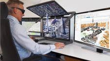
Schneider Digital has officially certified the compatibility of Esri's ArcGIS Pro software with the entire 3D PluraView monitor product family. ArcGIS Pro integrates important functionalities from photogrammetry, such as importing...

A solution to quickly and easily measure the progress of a construction project has been presented by GeoSLAM, a leading simultaneous localization and mapping (SLAM) technology company. After working closely...

The latest GNSS technologies from CHCNAV have been used in combination with vocational training on the island of Sumatra to improve the productivity of surveying activities and hence contribute to...

It can be difficult to get the most out of point clouds, and precise classification is a costly, labour-intensive undertaking. There should be a tool that makes it easier… and...

Calculating and reporting stockpile inventories is now easier and faster in the latest version of the Virtual Surveyor drone surveying software. Virtual Surveyor Version 8.2 enables users to accurately calculate...
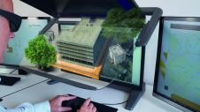
The cooperation between Schneider Digital and Xeometric/ Elitecad optimally combines the strength of 3D planning capabilities and stereoscopic graphic output. Three-dimensional modelling and design with Elitecad can be viewed stereoscopically...

Hexagon’s Geosystems division and Dutch company Cyclomedia are partnering in the latter’s mission to create a complete digital twin of the Netherlands. The Dutch use HxDR, Hexagon’s cloud-based visualization and...
This site uses cookies. By continuing to use this website, you agree to our Cookies Policy. Agree