The Surveyor’s Need to Embrace Data Management
Read this interview with Topcon's Ulrich Hermanski for his views on the current status of the surveying profession, the key advances and the future role of surveyors. Since graduating in...

Read this interview with Topcon's Ulrich Hermanski for his views on the current status of the surveying profession, the key advances and the future role of surveyors. Since graduating in...
As remotely sensed data becomes more and more ubiquitous, organisations are looking for ways to correctly use and manage this information. Lawrie Jordan, director of imagery for Esri asks organisations...
Ridge-Soft has announced the immediate availability of GDS 2011. This solution introduces Multi Image Provider (MIP), a secure, highly compressed and lossless image format for transferring large-sized imagery over the...
The GeoSpatial Solutions (GSS) division of Merrick & Company has made the new version 6.0 Merrick Advanced Remote Sensing (MARS) software suite available online. Geospatial users interested in evaluating MARS...
In 2004 the government agency responsible for water management in The Netherlands began a project to create an integrated geo-database for holding all geo-information on water-related objects. The set-up of...
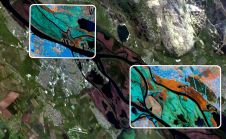
European Space Imaging (EUSI) has recently have announced a strategic partnership giving users direct access to the world's most detailed hyperspectral imagery from Pixxel. Combined with EUSI’s capability to build...

Vegetation and utility management of distribution and transmission lines has become one of the key applications related to Lidar and photogrammetry. The infrastructure sector, and especially the power line industry,...

Crunchy Data, a leading provider of open source PostgreSQL technology, support, and training, has announced its commitment to providing open source geospatial data management and analytics engineering and support by...
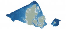
Through the collaborative implementation of satellite-derived bathymetry (SDB), the Danish Geodata Agency and EOMAP are synergizing efforts to contribute to the European Marine Observation and Data Network (EMODnet) Bathymetry partnership....
This site uses cookies. By continuing to use this website, you agree to our Cookies Policy. Agree