Pointly: How to Unlock the Power of Point Cloud Data
It can be difficult to get the most out of point clouds, and precise classification is a costly, labour-intensive undertaking. There should be a tool that makes it easier… and...

It can be difficult to get the most out of point clouds, and precise classification is a costly, labour-intensive undertaking. There should be a tool that makes it easier… and...

FIG has been bringing surveyors and geospatial experts together since 1878, and this year is no exception. Apart from the inauguration in 1878 and the second meeting in 1910, surveyors...

In view of the ongoing pandemic situation, ISPRS is organizing an extended digital edition of the XXIV Congress from 5-9 July this year, with all the features of an ISPRS...

The Open Geospatial Consortium (OGC) has announced the election of Patty Mims, Javier de la Torre and Prashant Shukle to its board of directors. The new appointments bring experience in...

EagleView's Integrated Pictometry Application (IPA) can now be launched from the Cityworks Esri map viewer. This new integration simplifies the asset management workflow for users in Canada by allowing them...
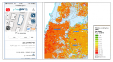
These five practical examples from Israel illustrate the role of governments, spatial data and technologies in developing a smart nation. The Fourth Industrial Revolution brings about new advancement and abilities...

Rafael Ponce graduated from the Mexican Naval Academy and served for 25 years in the Mexican Navy, on board destroyers and other vessels, and was CO of a hydrographic ship....

Recent technological developments have made aerial surveying more exciting than ever. For imagery, ground resolutions of 2cm can now be reached, whereas for Lidar, pulse frequencies of 4GHz and point...

In his latest column, Wim van Wegen reflects on digital technology as the leitmotif in Germany's role as a powerhouse within the geospatial industry. Traditionally, Germany is the heart of...
Richard Cooke, director of imagery at Esri, explains all about the company's acquisition of nFrames, the innovative Germany-based developer of software for 3D reconstruction from images. Esri recently made headlines...
This site uses cookies. By continuing to use this website, you agree to our Cookies Policy. Agree