Lidaretto
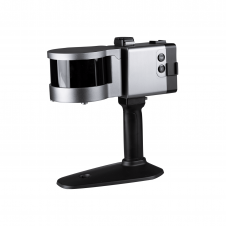
Lidaretto is flexible and compact Lidar scanning system developed since 2015 and uniquely designed to be used the way that fits best to users’ specific application. You can easily mount...

Lidaretto is flexible and compact Lidar scanning system developed since 2015 and uniquely designed to be used the way that fits best to users’ specific application. You can easily mount...
ComNav has announced the launch of its latest innovation: the LS300 3D laser scanner. This addition to the company's product lineup signifies a significant leap forward in addressing the dynamic...
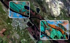
European Space Imaging (EUSI) has recently have announced a strategic partnership giving users direct access to the world's most detailed hyperspectral imagery from Pixxel. Combined with EUSI’s capability to build...

The organizers of Geo Week have released a preview of two keynote sessions for 2024: 'The Bright Future Ahead: Navigating AEC, 3D, and Geospatial Innovation and Change', and 'Geospatial for...
A global audience of geospatial professionals witnessed the presentation of the JOUAV VTOL Hangar, a groundbreaking development in the field of vertical take-off and landing (VTOL) drones, at Intergeo 2023....
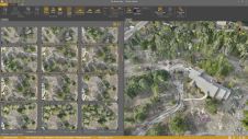
Virtual Surveyor has added drone photogrammetry capabilities to the latest release of its popular Virtual Surveyor smart drone surveying software. The new Terrain Creator app photogrammetrically processes drone photos to...
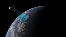
In a new partnership, Sanborn will use Pixxel’s hyperspectral dataset to equip its customers with advanced insights to solve problems as varied as agriculture crop and forestry health monitoring, exploration for...
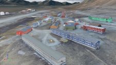
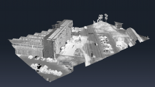
Nestled in the high Arctic Archipelago of Svalbard, the Sveagruva coal mine and mining settlement once buzzed with activity until its closure in 2016. An extraordinary project is now underway...
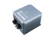
Advanced Navigation has unveiled an expansion of its Boreas digital fibre-optic gyroscope (DFOG) range with the introduction of the new A Series. This development showcases the company’s commitment to meeting...
Since the explosion of Lidar over the past two decades, the use of point clouds in aerial mapping applications has become common these days. However, Lidar is not without its challenges. This article explores how colourized point clouds from photogrammetry can offer a value-adding alternative. Since the explosion of Lidar over the past two decades, the use of point clouds in aerial mapping applications has become common these days. However, Lidar is not without its...
This site uses cookies. By continuing to use this website, you agree to our Cookies Policy. Agree