UAV Remote Sensing for Smart Agriculture
‘Smart agriculture’, i.e. the efficient use of Earth's resources to feed the world, requires accurate and advanced data acquisition, modelling and management. UAVs can play a critical role in this....
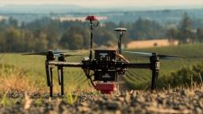
‘Smart agriculture’, i.e. the efficient use of Earth's resources to feed the world, requires accurate and advanced data acquisition, modelling and management. UAVs can play a critical role in this....
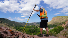
ComNav Technology has launched a laser GNSS receiver which enables rodless surveys – the Venus Laser RTK – as part of its new Universe series of GNSS receivers. Surveyors in the...
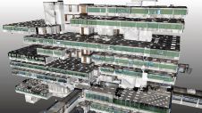
IBKS is a digital solutions and management consulting firm offering built-environment services in the healthcare space. The firm recently tested its innovative NavVis and PointFuse workflow in a huge, complex...

In which direction is the geospatial industry heading? Which core activities will companies focus on? How will the rapidly progressing technological advances shape the future? The recent edition of HxGN...

NavVis and several partners, including GIM International, recently conducted a global study among surveying and scanning professionals in the laser scanning, surveying and AEC industries. The goal of the study,...

NavVis, the German provider of reality capture and digital factory solutions, is capturing BMW Group’s worldwide plants and making the photorealistic panoramic images, floor plans and point cloud data available...
NavVis is partnering up with AVEVA to provide users with the technology to access reliable as-built 3D point cloud data and panoramic images. NavVis is known for its advanced reality capture,...

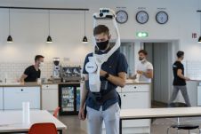
The laser scanning and surveying industries are undergoing a seismic shift. Mobile mapping technology is radically changing the way we work, reinventing workflows, and generating whole new categories of deliverables. Today,...
What is the current state of GNSS, from both a constellation, augmentation and receiver perspective? Spoiler alert: it is more of an evolution than a revolution! It is almost impossible...

4Indoor has used a wearable NavVis VLX mobile mapping system to create a high-quality 1.2GB point cloud of the medieval gateway called Koppelpoort in the Dutch city of Amersfoort. 4Indoor,...
This site uses cookies. By continuing to use this website, you agree to our Cookies Policy. Agree