Do GIS Professionals Understand their Own Industry Well Enough?
As the power of locational data starts to dawn on a wider range of industries, the GIS profession needs to ensure that it understands the fast-changing world within which it...

As the power of locational data starts to dawn on a wider range of industries, the GIS profession needs to ensure that it understands the fast-changing world within which it...
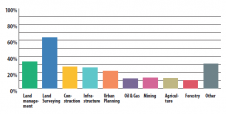
In 2008, the seemingly endless growth of the geomatics industry was rudely interrupted by the global economic crisis and its enduring after-effects. But now, ten years later, the readers’ survey...

Michel Assenbaum was educated as an engineer and holds a PhD in physical oceanography from Toulouse University, France. Alongside his role as president of YellowScan, he pursues research activities in...
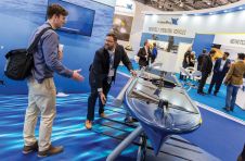
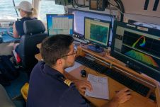
London’s docklands became home to a fleet of both manned and unmanned surface and subsea vehicles during this year’s Oceanology International 2018 (Oi18), reflecting an increasing focus on connected autonomous...
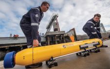
Since the last autonomous underwater vehicle (AUV) review in 2016, the market has continued to grow. The biggest market for AUV systems remains the military. The world’s most advanced navies...
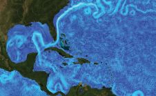
Oceanographic equipment developed by underwater technology company Sonardyne International will be used as part of a major US$2 million scientific study of disruptive ocean currents in the US Gulf of...
According to NOAA (The U.S. National Oceanic and Atmospheric Administration), hydrography is the science that measures and describes the physical features of the navigable portion of the Earth's surface and...
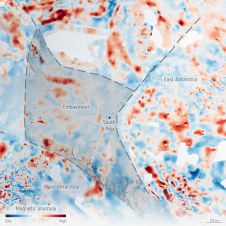
An ESA-funded campaign called PolarGAP has used airborne sensors to take a multitude of measurements to fill in the gaps in satellite coverage over the North and South Poles. It...
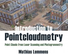
‘Introduction to Pointcloudmetry’ is the title of the new book by Mathias Lemmens, former editor-in-chief of GIM International. Despite the in-depth text, it is a clearly and accessibly presented book...

Global reference systems such as the International Terrestrial Reference Frame provide the foundation for determining positions on Earth and in space, as well as for reliably quantifying our planet’s changes...
This site uses cookies. By continuing to use this website, you agree to our Cookies Policy. Agree