Oil Spill Monitoring in Western Australia
EOMAP GmbH & Co has launched several services to support oil spill monitoring using optical satellites. The services were developed for mapping a major ecological disaster: a recent oil spill...
EOMAP GmbH & Co has launched several services to support oil spill monitoring using optical satellites. The services were developed for mapping a major ecological disaster: a recent oil spill...
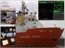
Greater tracking reliability and enhanced decision-making data are available for the Fanbeam laser-based marine positioning system with the launch of new control software from Measurement Devices Ltd (MDL), a leading...
Veripos, a world leader in the provision of precise Global Navigation Satellite System positioning solutions to the offshore oil and gas industry, has been commissioned by ARIS Geophysical of Moscow...

Electromagnetic Geoservices ASA (EMGS) has entered into a data-licensing agreement with Rocksource, in which Rocksource pre-committed to license newly acquired Clearplay Test EM data over a number of prospects in...

Between August and November 2009 as requested by Lukoil-Nizhnevolzhskneft, ScanEx Research and Development Center completed the project for satellite monitoring of oil pollution in the North Caspian region. The project...

Final permission has been granted to Nord Stream AG to start construction of a natural-gas pipeline through the Baltic Sea. All permits required by the four countries through whose territorial...
Hexagon has entered into an agreement to acquire US-based software provider Intergraph Corporation. The transaction, at a value of USD2,125 million, is financed on cash basis. The acquisition will strengthen...

The Deepwater Horizon drilling rig was built in 2001 as a semi-submersible platform specially designed for operations in ultra-deep water. The rig employs a dynamic positioning system to maintain a...
Aberdeen (UK)-based Veripos, GNSS positioning specialists for the the world offshore industry, plan to present their latest technical developments in the US with key stand displays at the MTS Dynamic...
At INTERGEO 2010, Applanix has announced a new version of its post-processing software for Mobile Mapping and Positioning, POSPac MMS version 5.4. Designed to enhance the productivity of Mobile Mapping,...
This site uses cookies. By continuing to use this website, you agree to our Cookies Policy. Agree