A Drone Survey of a Wind Farm Access Road
Maintaining a large wind farm requires constant and reliable access. UAV technology was successfully used to survey the construction of an access road in a recent project in Norway. Drone...
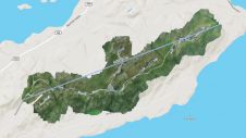
Maintaining a large wind farm requires constant and reliable access. UAV technology was successfully used to survey the construction of an access road in a recent project in Norway. Drone...
At the height of the pandemic, our annual industry survey revealed the key challenges to be remote working and balancing productivity with employee well-being. Now that COVID-19 restrictions are gradually...

Following its emergence more than a decade ago, digital twin technology has developed to become a complex and comprehensive technical system that supports the construction of new smart cities. It...

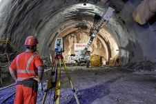
There is a general acknowledgement in the scanning and mapping industry that, compared to terrestrial laser scanners (TLS), mobile mapping systems significantly increase scanning speed and point cloud coverage. This is especially true for building interiors and equipment. This results in reduced time on site, which in turn lowers the cost of scanning for the service provider. There is a general acknowledgement in the scanning and mapping industry that, compared to terrestrial laser scanners (TLS), mobile mapping systems significantly increase scanning speed and point cloud coverage. This...

Accurate bathymetric mapping of shallow areas is essential for many offshore activities. Through Structure from Motion (SfM) and Multiview Stereo (MVS) techniques, images can provide a low-cost alternative compared to Lidar...

Land Information New Zealand (LINZ) recently launched LINZ Basemaps – a digital mapping background that provides context on which additional layers of information can be overlaid. LINZ’s acting chief executive...

No statistics could possibly convey the importance of energy to our economies and everyday lives. Nearly everything people interact with on a daily basis has a source of power. Growth...
Land Information New Zealand (LINZ) recently launched LINZ Basemaps – a digital mapping background that provides context on which additional layers of information can be overlaid. LINZ’s acting Chief Executive...
The concept of Satellite Structural Health Monitoring (S-SHM) was conceived as a new way of analysing and understanding the behaviour of assets and infrastructures as a whole, integrated in their...

FIG Commission 5 focuses on meeting the highest level of accuracy for Positioning and Measurement. It provides the tools, techniques and procedures to educate and train surveying professionals everywhere. Appropriate...
This site uses cookies. By continuing to use this website, you agree to our Cookies Policy. Agree