Diane Dumashie Elected as New President of FIG
Dr Diane Dumashie won the final vote at the FIG Congress 2022 in Warsaw and will serve as the next president of FIG for the next four years. She stated...

Dr Diane Dumashie won the final vote at the FIG Congress 2022 in Warsaw and will serve as the next president of FIG for the next four years. She stated...

The World Bank has approved a US$41.1 million International Development Association (IDA) grant to support the establishment of an efficient and accessible land administration system in Sierra Leone. The project...

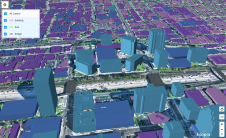
When it comes to utilizing the true potential of digital twin technology, Singapore is miles ahead of most other governments. Even those that have already embraced the concept of the...

EuroGeographics has welcomed the strengthening of the UN-GGIM mandate and Secretariat resources. “The resolution adopted by the UN’s Economic and Social Council (ECOSOC) recognizes that a strong global geospatial infrastructure...
Ecopia AI has entered a CAD8 million dollar funding partnership with Sustainable Development Technology Canada, which will support the creation of high-precision 3D vector maps across the top 100 cities...

Diversity and inclusion (D&I) are high on the FIG agenda, and this was reflected in one of the keynote sessions during FIG Working Week 2021. The session was thought-provoking on...

The German Federal Agency for Cartography and Geodesy (BKG) is creating a digital twin of the whole of Germany that can be used to simulate various future scenarios in order...

Genesys International intends to make a digital twin of the whole of urban India. The launch programme was inaugurated by Amitabh Kant, chief executive officer of the National Institution for...

Powerhouses of photogrammetry and remote sensing science and industry are set to gather in Nice, France, for the XXIV Congress of the International Society for Photogrammetry and Remote Sensing (ISPRS) from 6-11 June 2022. Powerhouses of photogrammetry and remote sensing science and industry are set to gather in Nice, France, for the XXIV Congress of the International Society for Photogrammetry and Remote Sensing (ISPRS)...
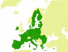
Official geospatial data from Europe’s national mapping, cadastral and land registration authorities has a key role to play in achieving the aims of the European Union (EU) Green Deal. This...
This site uses cookies. By continuing to use this website, you agree to our Cookies Policy. Agree