UAV Remote Sensing for Smart Agriculture
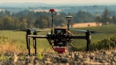
‘Smart agriculture’, i.e. the efficient use of Earth's resources to feed the world, requires accurate and advanced data acquisition, modelling and management. UAVs can play a critical role in this....
‘Smart agriculture’, i.e. the efficient use of Earth's resources to feed the world, requires accurate and advanced data acquisition, modelling and management. UAVs can play a critical role in this....

Airbus and VDL Group have entered into a strategic partnership to jointly develop and manufacture a cutting-edge laser communication terminal, named UltraAir. The partnership builds on the research and development...
Markku Markkula is the president of the Helsinki-Uusimaa Region (chair of the board). He is vice-president of the European Committee of the Regions (CoR), having been the CoR president from...

Flai is on a mission to automate the extraction of custom user-driven products from Earth observation datasets by deploying state-of-the-art Artificial intelligence (AI) solutions. Our main focus is the analysis...

SaeHan Aero Survey has become the first customer in Korea to purchase the IGI UrbanMapper-2P. This nadir and oblique imaging system will be operated together with IGI’s LM-7802S, a high-performing...
Presagis has partnered with Airbus Defence and Space to give Presagis customers direct access to the OneAtlas satellite image library from inside its Velocity 5D (V5D) digital twin production platform....

EuroGeographics will showcase next-level mapping for modern-day data infrastructures at the European Parliament on 29 November. The debate with MEPs and policymakers, organized by Cristian Bușoi, chair of the European...
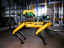
Trimble and Exyn Technologies, a pioneer in multi-platform robotic autonomy for complex, GPS-denied environments, have entered a strategic collaboration to explore the use of autonomous construction surveying technology. The solution...

“We are on a highway to climate hell,” said Antonio Guterres at COP27. So how can the geospatial industry help society to find the nearest exit? Despite certain people still...

Vexcel Imaging has released the new UltraCam Eagle 4.1, aimed at increasing flight efficiency at truly mapping-grade image quality for precise analysis and interpretation. The company itself describes this solution...
This site uses cookies. By continuing to use this website, you agree to our Cookies Policy. Agree