Reflections on HxGN LIVE Global 2023
It is time to innovate with technology that can be applied ‘right here, right now’. That was the clear message during HxGN LIVE Global 2023. President and CEO Paolo Guglielmini...

It is time to innovate with technology that can be applied ‘right here, right now’. That was the clear message during HxGN LIVE Global 2023. President and CEO Paolo Guglielmini...
CHC Navigation has introduced the C5 and C30 aerial survey cameras offering more precision and efficiency in aerial photogrammetry. These sophisticated cameras seamlessly integrate with unmanned aerial vehicles (UAVs or...
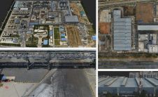
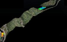
Ordnance Survey, the national mapping agency for Great Britain, was in need of a faster and more cost-effective way to collect georeferenced point cloud data, because the existing method was not sustainable in the long term. The Ordnance Survey team turned to Datron Technology and OxTS to help them develop a convenient, low-cost, ‘off-the-shelf’ mobile mapping system. Ordnance Survey, the national mapping agency for Great Britain, was in need of a faster and more cost-effective way to collect georeferenced point cloud data, because the existing method was...
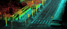
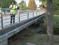
Israel’s national roads company is embarking on a large-scale, multi-year project to digitize its entire network. Surveying company Kav Medida has been awarded the contract to map the northern half...
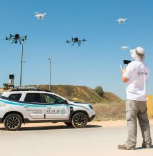
The Dutch startup Aerial Precision recently demonstrated its first two sensors with integrated artificial intelligence software. Over the past few years, the company’s innovation efforts have resulted in products that...

At OxTS, in line with our brand promise of being inertial navigation experts, our commitment to our customers is that we will keep innovating until we can help them truly ‘navigate anywhere’ – with or without GNSS. We are advancing our products in that direction by first enhancing urban navigation data quality based on sensor fusion. Here, we explain how. At OxTS, in line with our brand promise of being inertial navigation experts, our commitment to our customers is that we will keep innovating until we can help them truly...
ComNav Technology has introduced a new product called Venus Laser RTK, which allows positioning without the need for a range pole. For the prism-free total station, the principle behind this...
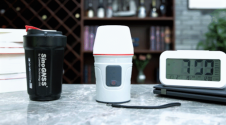
ComNav Technology has launched a laser GNSS receiver which enables rodless surveys – the Venus Laser RTK – as part of its new Universe series of GNSS receivers. Surveyors in the...
Topodrone, a Swiss-based designer and manufacturer of high-precision Lidar equipment for installation on drones, vehicles and backpacks, has launched Aquamapper, a UAV-based solution for bathymetric surveying and marine construction. The...
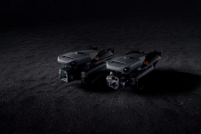
DJI has introduced its new DJI Mavic 3 Enterprise series designed to reimagine what drones can do for business, government, education and public safety. The DJI Mavic 3E and DJI...
This site uses cookies. By continuing to use this website, you agree to our Cookies Policy. Agree