Enabling UAV-Lidar to Fly Higher
Innovations in Lidar technology continue to change the way we see our world – literally. There’s no denying that the Lidar sector is growing at an exponential rate. Research by...

Innovations in Lidar technology continue to change the way we see our world – literally. There’s no denying that the Lidar sector is growing at an exponential rate. Research by...

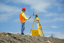
CHC Navigation (CHCNAV) has announced the availability of the i83 GNSS receiver, a new and innovative addition to its premium GNSS receiver series for surveying, mapping and construction professionals. The...

SSatellite surveying… are there any industry professionals out there not using it on (almost) a daily basis? In this issue of GIM International we highlight the recent developments in positioning and navigation systems and investigate how new solutions are set to bridge the gap between RTK and PPP. Additionally, we focus on the creation of a digital twin of Germany and on the development of a virtual terrestrial laser scanner simulator as a training tool to support the learning of laser scanning processes. Satellite surveying… are there any industry professionals out there not using it on (almost) a daily basis? In this issue of GIM International we highlight the recent developments in positioning...

What is the current state of GNSS, from both a constellation, augmentation and receiver perspective? Spoiler alert: it is more of an evolution than a revolution! It is almost impossible...

Besides the surveying hardware & software and the intricacies of BIM and data exchange, this article explores broader aspects of digitalization in the construction industry. How are they affecting the...

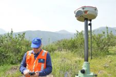
By applying Beidou technology, ComNav Technology has yielded fruitful results in African land mapping, continuous operating reference station (CORS) construction, precision agriculture and other fields over the past decade. Every...
ComNav Technology has announced a global upgrade of the T300 and T300 Plus GNSS receiver, including the upgrade to the new GNSS K8 platform on both receivers and the replacement...

How accurate is accurate enough? If you’re like most land surveyors, the answer is “as much as possible.” With an RTK drone, surveyors and other drone pilots can expect centimetre-level...
Trimble has introduced the R750 modular GNSS receiver, a connected base station for use in civil construction, geospatial and agricultural applications. The R750 provides improved base station performance, giving contractors,...

Surveyors and GIS professionals have the highest standards when it comes to their tools and trade. It is therefore no wonder that many surveyors are turning to drones for their mapping and...
This site uses cookies. By continuing to use this website, you agree to our Cookies Policy. Agree