Assessing environmental changes with GNSS reflectometry
An innovative geodetic tool called GNSS-IR is a more effective technique than tide gauge for monitoring sea surface height as the basis for modelling sea level variations, according to the...

An innovative geodetic tool called GNSS-IR is a more effective technique than tide gauge for monitoring sea surface height as the basis for modelling sea level variations, according to the...

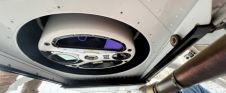
HERON MS TWIN Color is a SLAM-based system with the only capture head on the market featuring double lidar (32 chs - Max range: 120/300 m) and an 8K pano...

Smart Delta has entered into partnership with Cyvl.ai, combining mobile mapping experience with AI expertise. Smart Delta views this step as a powerful new opportunity to address challenges and discover...

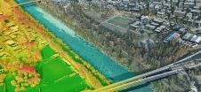
NV5 has recently completed the largest single oblique imagery collection in the USA for the Commonwealth of Kentucky. Spanning roughly 100,000 square kilometres and offering rich detail at three-inch (approx....

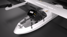
Diamond Aircraft has delivered the new DA62 MPP SurveyStar to RIEGL. Setting a new standard for high-capability, low-cost airborne survey missions, this robust and modern survey configuration variant of the...

Fujitsu has presented a pioneering technology that harnesses Lidar and AI to capture high-resolution 3D data of organisms, coral reefs and man-made structures such as offshore wind turbines using autonomous...
The University of Nacional Autónoma de México (UNAM) has recently procured a RIEGL VQ-1560 II-S airborne system through its Institute of Geography. It has been added to the R&D project...
Leica Geosystems, part of Hexagon, has launched the Leica TerrainMapper-3 airborne Lidar sensor, featuring new scan pattern configurability to support the widest variety of applications and requirements in a single...

The Earth observation industry seems to be on a slow burn – but why? Brace yourself for a ‘rollercoaster ride’ through Earth observation as this article unravels the mysteries behind...
JOUAV has released the JoLiDAR-1000 Lidar sensor designed specifically for uncrewed aerial vehicles (UAVs or ‘drones’) as the latest addition to its array of high-performance Lidar sensors for use in...
This site uses cookies. By continuing to use this website, you agree to our Cookies Policy. Agree