Swarm Technology for UAS Mapping
The vision of multiple drones mapping remote areas autonomously is realized by the Swiss senseFly’s ground control software. This technology was then adapted by senseFly’s R&D team and first sucessfully...

The vision of multiple drones mapping remote areas autonomously is realized by the Swiss senseFly’s ground control software. This technology was then adapted by senseFly’s R&D team and first sucessfully...

Having signed a five-year sponsorship with BYU University of Utah, USA, Pix4uav has recently been used to create the first ever detailed map of the Ad Deir Plateau in Petra,...

Trimble (USA) has introduced its Unmanned Aircraft System (UAS): the Trimble UX5 aerial imaging rover with the Trimble Access aerial imaging application. The solution builds upon its predecessor, the Trimble...
Woolpert, an American geospatial, infrastructure management and design consulting firm, has purchased its first UAS, the Nova Block III, from partnering UAS firm Altavian. The Nova Block III is an...

An Unmanned Aerial System (UAS) was used to acquire images of a small area in Italy for the purpose of post-landslide monitoring. The entire chain from aerial survey up to...

PIEneering, Finland, has released a complete photogrammetric software system, RapidStation suite, for processing digital imagery acquired with Unmanned Aerial Systems (UAS), aircrafts and helicopters. The software suite covers the entire...

The use of a UAS to acquire geodata for mapping purposes has evolved beyond infancy and is now rapidly maturing. How will it evolve in the foreseeable future? The use...

RIEGL has recently added the VUX-18024, a lightweight and versatile UAV-Lidar sensor for high-speed surveying missions, to its portfolio. This once again underlines the Austrian company’s pioneering role as a...
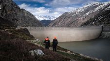
In early 2021, the Orthodrone team crowded itself and its equipment into a tiny Swiss gondola and made its way to one of two dams scheduled for water-side inspection –...
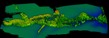
Wetlands are essential ecosystems which provide numerous benefits to society as a whole. But their functionality strongly depends on the hydrology and topography of the watershed, thus creating the need...
This site uses cookies. By continuing to use this website, you agree to our Cookies Policy. Agree