Cartomorphosis: an evolution that starts with cadastre
Over the past 15 years, geospatial information has enabled the transformation of towns, cities and a whole state in Mexico. The customer and data provider teamed up to create up-to-date...
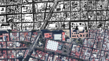
Over the past 15 years, geospatial information has enabled the transformation of towns, cities and a whole state in Mexico. The customer and data provider teamed up to create up-to-date...
Blue Marble Geographic’s flagship software, Global Mapper Pro, is an all-in-one GIS package for analysing and processing vector, terrain, image and point cloud data. Compatible with over 380 different file...
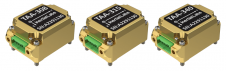
Inertial Labs has unveiled its latest innovation: high-precision three-axis accelerometers (TAA). These compact, self-contained devices mark a significant leap forward in navigation-grade accelerometers, promising unmatched precision in measuring linear accelerations....
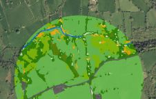
The UK’s Peak District National Park Authority is pioneering the use of artificial intelligence (AI) to automate the production of highly detailed land cover maps, in a project in partnership...

Both vertical and oblique aerial images have their own advantages, making them valuable in different reality mapping applications. So how can you choose between the two? This comparison will help...

In a high-flying endeavour spanning over six decades, the UK’s National Grid's fleet of advanced helicopters have been diligently patrolling pylons and power lines, ensuring the health and reliability of...
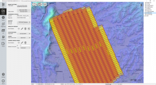
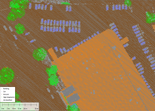
The TatukGIS Developer Kernel (DK) plays a key role in the Topoflight software suite (Missionplanner for optimal flight paths, and Navigator for precise data acquisition). In the realm of vast...

Recently unveiled by Vexcel Imaging, the groundbreaking UltraCam Dragon 4.1 represents one of the market's most advanced, progressively designed and seamlessly integrated hybrid aerial mapping systems. Tailored for high-resolution mapping...

RIEGL has recently added the VUX-18024, a lightweight and versatile UAV-Lidar sensor for high-speed surveying missions, to its portfolio. This once again underlines the Austrian company’s pioneering role as a...

In the rapidly evolving landscape of geospatial technology, the annual Trimble Dimensions gathering is a dependable beacon for the surveying and mapping fields, providing a panoramic view of the current...
This site uses cookies. By continuing to use this website, you agree to our Cookies Policy. Agree