Bluesky Aerial Photography Helps Economic Growth
High resolution aerial photography from Bluesky is helping Darlington Borough Council produce plans of Council owned land, in order to promote growth and development in the North East of England...
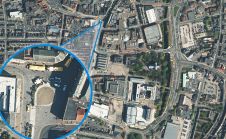
High resolution aerial photography from Bluesky is helping Darlington Borough Council produce plans of Council owned land, in order to promote growth and development in the North East of England...
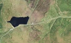
Bluesky has supplied high resolution aerial photography for a major conservation project to protect and transform moorlands in northern England. Purchased by The Moors for the Future Partnership, as part...
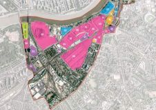
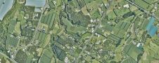
Aerial photography from Bluesky, UK, has been used to create an interactive map illustrating the regeneration project that is transforming London’s South Bank. The project is set to metamorphose the...

Thanks to a partnership with Blom UK, Bluesky International is now able to offer BlomOBLIQUE aerial images of hundreds of European cities, and more are being added to the online...
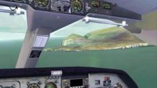
Getmapping’s aerial photographic survey of Scotland is being compiled into a comprehensive set of terrain scenery by Horizon Simulation for the popular Microsoft Flight Simulator, ‘Generation X’ edition. The first...
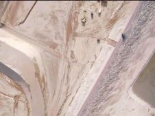
Kragten has fulfilled a trial with the X100 of Gatewing, an Unmanned Aerial Vehicle (AUV), equipped with a camera. The airplane as mapped an area of 1,200 x 1,400m with...
Following an agreement between aerial survey specialist Bluesky and Getmapping the original images that make up the Millennium Map will now be available from www.oldaerialphotos.com. Billed at the time as...
Land Information New Zealand has made 20TB of aerial imagery available for free for the first time in a cloud-optimized format on Amazon Web Services (AWS), making it easier and...

The aerial survey system for upgrading digital maps of Qatar has become operational. Under the aerial surveys project for Qatar, the mission of aerial photography covering all parts of the...
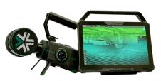
Exyn Technologies has unveiled Exyn Nexys, an innovative modular 3D mapping solution. Designed for professionals in the mining, construction, AEC and geospatial industries, Nexys aims to set a new standard...
This site uses cookies. By continuing to use this website, you agree to our Cookies Policy. Agree