Doubling Airborne Lidar Data Acquisition
Leica Geosystems' Point Density Multiplier technology for airborne Lidar allows the use of a single laser and scanning mechanism to provide over double the data collection productivity of previous systems....

Leica Geosystems' Point Density Multiplier technology for airborne Lidar allows the use of a single laser and scanning mechanism to provide over double the data collection productivity of previous systems....
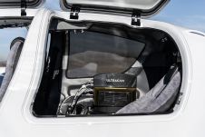
Diamond Aircraft and Vexcel Imaging have announced the next collaboration for a further expansion of Diamond’s special mission aircraft high-end sensor portfolio. The partnership will integrate the UltraCam Dragon 4.1...

Visitor registration is now open for GEO Business, the UK's largest geospatial event. The free-to-attend expo, tailored for geospatial professionals seeking to harness the potential of location intelligence, will return...

Teledyne Geospatial has released the Galaxy Onboard, a workflow-focused solution that enables airborne surveyors to deliver quality-controlled processed data in real time. With Galaxy Onboard, Teledyne Geospatial has lowered the...
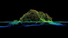
RIEGL tested the performance of its topobathymetric airborne laser scanning system in a transition zone context along the French Mediterranean coast. Initially planned as a UAV survey, tests were conducted...

With the rapid development of civil construction and the increasing demand for electricity in recent years, the market segment of power grid construction has grown significantly. Meanwhile, how to efficiently...
Trimble has unveiled the integration of the Trimble Applanix POSPac Cloud post-processed kinematic (PPK) GNSS positioning service, featuring CenterPoint RTX, with the UAV-based mapping and data collection capabilities of DroneDeploy’s reality...

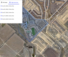
Transport Canberra and City Services (TCCS) recently engaged 1Spatial, a leading company in managing geospatial data, to analyse and extract aerial laser scanning data. The project was aimed at accelerating the...

Today, automatic matching of overlapping aerial imagery and airborne Lidar are the main geodata technologies for capturing dense point clouds of the Earth’s surface. The sampled points are used for...

Mr Judah Westby, regional sales manager at Teledyne Optech, will deliver a presentation on the multi-spectral Optech Titan during the Asian Conference on Remote Sensing (ACRS) taking place from 19-23...
This site uses cookies. By continuing to use this website, you agree to our Cookies Policy. Agree