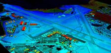
VeriDaaS Plans Statewide California Lidar Mapping Project in Spring 2021
VeriDaaS is planning a high-density Lidar elevation data collection at a minimum of 30 points per metre (ppm) over the entire state of California in spring 2021 as part of...
VeriDaaS is planning a high-density Lidar elevation data collection at a minimum of 30 points per metre (ppm) over the entire state of California in spring 2021 as part of...
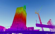
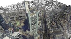
When it comes to 3D modelling for construction, what are the advantages and disadvantages of photogrammetry versus Lidar in terms of accuracy, complexity and cost? Breaking away from laser measurement...

Stephen Quick is an adjunct in the School of Architecture teaching the first-semester design studio in the Masters of Urban Design program. He returned to teach in the Urban Design...
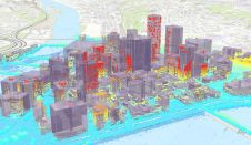
Working with Pittsburgh’s City Planning Department, a Carnegie Mellon University research team completed an in-depth study of the current use of 3D software for planning tasks and public communication.[1] The team...

In this interview, Thomas Harring emphasizes that the geospatial industry should use the momentum of the ‘new normal’ to further accelerate the sector’s ongoing transformation towards more customer-centric and autonomous...
Richard Cooke, director of imagery at Esri, explains all about the company's acquisition of nFrames, the innovative Germany-based developer of software for 3D reconstruction from images. Esri recently made headlines...

This webinar gives you insights into our recently introduced UltraCam Osprey 4.1, its system architecture, key features, data processing and visualization. Alexander Wiechert, CEO of Vexcel Imaging, and Bernhard Schachinger,...

The Spanish high-resolution land imaging mission, known as SEOSAT-Ingenio, will soon be shipped from Airbus in Madrid to Europe’s Spaceport in French Guiana, where it will be prepared for launch...
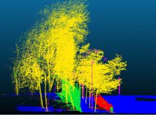
A deep learning architecture called MMCN opens up the possibility for the fully automated classification of highly dense 3D point cloud data acquired from a mobile Lidar system. This offers...
Esri has announced its acquisition of nFrames, a German technology company that develops SURE, an industry-leading imagery and Lidar 3D surface reconstruction software. This will enable the fusion of imagery...
This site uses cookies. By continuing to use this website, you agree to our Cookies Policy. Agree