Using BIM data together with city models
An increasing number of cities are creating 3D city models to support visualization and simulations in the urban planning process. The 3D city models are often extended with planned buildings....
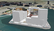
An increasing number of cities are creating 3D city models to support visualization and simulations in the urban planning process. The 3D city models are often extended with planned buildings....
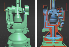
A recent project has celebrated 100 years of geodetic and photogrammetric innovation by 3D-digitizing an iconic WILD T2 theodolite from the 1927 series. An app has also been developed for...

Vexcel Imaging has released the next camera based on its 4th-generation camera architecture, the UltraCam Condor 4.1. The new camera addresses a very specific application: high-altitude ortho image generation with...

'GIM International' spoke to Blickfeld, a developer of Lidar sensors and software, to hear about other potentially relevant applications in smart cities, besides for autonomous driving. Despite the name, a self-driving...

On social media, the average post receives only a few seconds of attention. At trade shows, first impressions determine whether attendees visit a booth. The first moments also set the...

Globally adopted frameworks developed in the first decade of the United Nations Committee of Experts on Global Geospatial Information Management (UN-GGIM) are enabling Member States to unlock the true power of location-based...

The Open Geospatial Consortium (OGC) has announced that the OGC Membership has approved the CityGML v3.0 Conceptual Model for adoption as an official OGC Standard. Since its first publication by...
The Commercial UAV Expo is the place to learn about the most exciting new technologies in UAVs. Returning this year, it hosts an innovative solution with the official unveiling of Emesent’s...

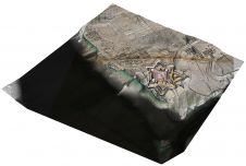
Switzerland-based professional drone company Wingtra has produced a high-precision digital twin of the city of Zurich that can be easily accessed by anyone through a link. Such rapid data collection...
Airborne Lidar and 3D modelling technologies were used at the historic site of Fort Anne in Nova Scotia, Canada, not only as an aesthetic recreation of history, but also to...
This site uses cookies. By continuing to use this website, you agree to our Cookies Policy. Agree