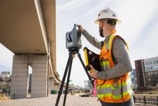
The good, the bad and the ugly of the surveying profession
In the early days of surveying, surveyors were pioneers in charting the unknown. Today, with the Earth having been completely mapped to some degree, surveying has become a much more...

In the early days of surveying, surveyors were pioneers in charting the unknown. Today, with the Earth having been completely mapped to some degree, surveying has become a much more...
Trimble has recently announced the Trimble X9 3D laser scanning system, a versatile reality capture solution for surveying, construction and engineering professionals. The X9 is built on Trimble's proven laser...
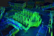
The National Institute for Immovable Cultural Heritage (NIICH) of Bulgaria recently presented the first results of a 3D mapping project of the ancient town of Nessebar. With a history spanning...

The NavVis VLX 3 has been unveiled as a groundbreaking advancement in reality capture technology. This is the latest addition to the NavVis VLX product family by the specialist in...

GEO Business will put the spotlight on geospatial innovation for two days long, from 17-18 May. At ExCeL London, around 3,500 geospatial professionals will come together to discover and debate...
Remote sensing surveys in Antarctica based on unmanned aerial vehicles (UAVs or ‘drones’) have become a very important approach for a wide range of studies. Mapping free-from-ice-and-snow terrain and monitoring...
Jürgen Mayer serves as the president of Hexagon’s Geosystems Reality Capture Division, drawing on his knowledge from his MSc in Surveying and Engineering from the Technical University of Vienna, Austria,...

Population growth, urbanization and rapid digitalization all represent global challenges, but they also offer opportunities for the geospatial industry, because reality capture technology is an essential part of the puzzle...
What are the primary technical differences between crewed and uncrewed aerial vehicles and satellites when it comes to capturing images of Earth? Where do they overlap, and where do they...

We asked James Kavanagh, head of land & resources with The Royal Institution of Chartered Surveyors (RICS), about the challenges facing the geospatial industry, the technological developments that will drive...
This site uses cookies. By continuing to use this website, you agree to our Cookies Policy. Agree