Capturing Reality in True-3D
A spin-off of two major European research Labs, Acute3D – whose name associates the notions of 3D and precision – develops innovative software solutions allowing simple photographs to be turned...
A spin-off of two major European research Labs, Acute3D – whose name associates the notions of 3D and precision – develops innovative software solutions allowing simple photographs to be turned...
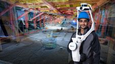
NavVis has announced the launch of NavVis VLX 2nd generation, a new iteration of the flagship mobile mapping system optimized for scanning both indoor and outdoor environments. NavVis is a...
CyberCity is an international 3D-geo-information company specialised in generation, distribution, analysis and visualisation of 3D-city and facility models and photo-realistic 3D-landmarks. The Swiss-based company with headquarters in Urdorf (Zurich) works...
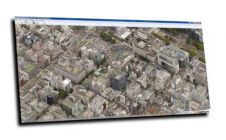
Working with Pittsburgh’s City Planning Department, a Carnegie Mellon University research team completed an in-depth study of the current use of 3D software for planning tasks and public communication.[1] The team...

After a slow start, the digital transformation is rapidly accelerating in the construction industry. These recent breakthroughs in reality capture are set to improve efficiency for the entire industry. According...

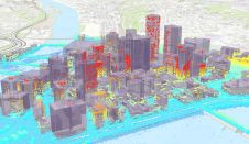
Cityscape Digital is using Bluesky's photorealistic 3D mesh models to create live, interactive 3D environments to illustrate proposed city developments. A specialist in computer-generated imagery (CGI) solutions for the property...

Arvizio recently has announced the integration of their MR Studio enterprise mixed reality platform with the Autodesk BIM 360 and A360 applications. The inclusion leverages the Forge API to seamlessly...
SenSat – a UK-based geospatial startup company using artificial intelligence to unlock value in the infrastructure industry based on digital representations of real-world locations – has announced a US$10 million Series A...

Leica Geosystems, part of Hexagon, has announced Leica Cyclone 3DR, the new reality capture software that fuses technology for centralised, full-scale point cloud management with advanced, automated point cloud analysis...

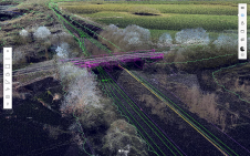
Topcon Positioning Group has rolled out a new real-time reality capture solution for building construction verification – the GTL-1000. The solution includes a compact scanner integrated with a fully featured...
This site uses cookies. By continuing to use this website, you agree to our Cookies Policy. Agree