Inspire the younger generation!
Two initiatives aimed at encouraging young individuals to pursue a career in mapping and surveying are highlighted by Wim van Wegen in this column. He hopes that they will trigger other...
Two initiatives aimed at encouraging young individuals to pursue a career in mapping and surveying are highlighted by Wim van Wegen in this column. He hopes that they will trigger other...
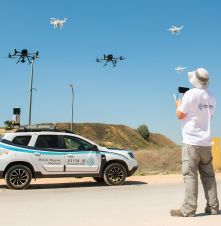
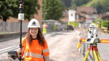
Israel’s national roads company is embarking on a large-scale, multi-year project to digitize its entire network. Surveying company Kav Medida has been awarded the contract to map the northern half...

As robots and autonomous technologies become increasingly integrated into surveying workflows, how are they changing the way the physical environment is mapped? As robots and autonomous technologies become increasingly integrated into surveying workflows, how are they changing the way the physical environment is mapped? This edition will explore how robots can support...
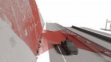
Exploring the complete potential of mobile laser scanning raises the question of whether the obtained results are sufficiently accurate for deformation monitoring. This article focuses on the geometric quality of...
The European Association of Aerial Surveying Industries (EAASI) organized a webinar on 'Reducing the Carbon Footprint of Aerial Surveying' on 26 May 2023. This virtual event brought together industry experts...
In the early days of surveying, surveyors were pioneers in charting the unknown. Today, with the Earth having been completely mapped to some degree, surveying has become a much more...
From drones and satellites to airborne-based sensors and Lidar, advances in remote sensing and geospatial information science are driving the development of innovative methods for data acquisition, processing and maintenance....
The NavVis VLX 3 has been unveiled as a groundbreaking advancement in reality capture technology. This is the latest addition to the NavVis VLX product family by the specialist in...

Leica Geosystems, part of Hexagon, has introduced the Leica Pegasus TRK100 as the latest addition to its portfolio of mobile mapping solutions. Specifically designed for GIS professionals, the new mobile...
SkyWatch has been selected by the Canadian Space Agency (CSA) to complete Phase 2 of the Artificial Intelligence and Big Data Analytics for Advanced Autonomous Space Systems challenge. This award...
This site uses cookies. By continuing to use this website, you agree to our Cookies Policy. Agree