Shaping Our World
According to top GIS educator and spatial thinker Dr Joseph Kerski, the development and use of geotechnologies is crucial not just as an educational tool, but also in determining the...
According to top GIS educator and spatial thinker Dr Joseph Kerski, the development and use of geotechnologies is crucial not just as an educational tool, but also in determining the...
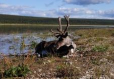
A meeting on the issues of application of space technology for monitoring and inventory of wild animals was held on 8th December, 2010 at ScanEx Research & Development Center. The...

The geospatial world gathered in Hyderabad, India, from January 18th to 21st at the Geospatial World Forum (GWF). With high-profile guests and delegates from all over the globe convening in...

The geospatial world gathered in Hyderabad, India, from January 18th to 21st at the Geospatial World Forum (GWF). With high-profile guests and delegates from all over the globe convening in...
The Society for Conservation GIS (SCGIS) and Esri are working together to bring special recognition to those involved in conservation initiatives, the International Conservation Mapping Competition is open to all...
PCI Geomatics, Canada, has appointed Dr. Alan Moses, the son of Dr. Robert (Bob) Moses, to the PCI Board of Directors. Alan has long been interested in the technology developed...
The ASPRS awards were presented during the ASPRS Annual Conference, held in March 2012 in Sacramento, USA. The Photogrammetric Award (Fairchild) was awarded to Dean W. Merchant, PhD, PE. This...

USGS scientists have developed a new method for mapping grasslands that demonstrate high potential for growing biofuel crops with relatively little energy input or environmental impact. The pioneering investigation used...

Caves are natural underground spaces formed and shaped over millions of years. Usually part of bigger caverns, they give a first-hand view of water, biology, oil and other subsurface distributions...

The University of Leeds, UK, has purchased a laser scanning system from 3D Laser Mapping. The RIEGL VZ-1000, which can capture highly accurate measurements from almost a mile away (1,400...
This site uses cookies. By continuing to use this website, you agree to our Cookies Policy. Agree