The Blueprint Towards Gender Neutrality in IT
London recently played host to over 3,000 GIS professionals. What made it different from many other IT events was the large proportion of female industry experts in attendance, making it...

London recently played host to over 3,000 GIS professionals. What made it different from many other IT events was the large proportion of female industry experts in attendance, making it...

GIS Professionals need to diversify their skills and quickly learn emerging technologies, argues Patrick Rickles. The use and understanding of GIS was historically limited to specialists. Today, GIS is commonplace,...
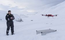
Drones are playing a crucial role in vital work to better understand the effects of climate change in the Arctic. Dr Joseph Cook, a glaciologist at the University of Sheffield,...
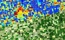
Emerging satellite data providers ConstellR and ScanWorld have announced a new partnership which aims to leverage combined Earth observation expertise to provide data-driven insights for agriculture and vegetation monitoring. The...
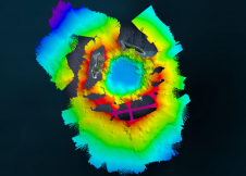
The Tonga Eruption Seabed Mapping Project (TESMaP) is a collaborative mission to discover the undersea impacts of the January 2022 eruption of the Hunga-Tonga Hunga-Ha’apai volcano. Using their collective knowledge,...

Fujitsu has presented a pioneering technology that harnesses Lidar and AI to capture high-resolution 3D data of organisms, coral reefs and man-made structures such as offshore wind turbines using autonomous...
This site uses cookies. By continuing to use this website, you agree to our Cookies Policy. Agree