FIG e-Working Week 2021: A Success Story of the New Reality
Bringing together over 1,300 participants from all over the world for a week packed with inspiring sessions, the FIG e-Working Week can be regarded as a success story of the...

Bringing together over 1,300 participants from all over the world for a week packed with inspiring sessions, the FIG e-Working Week can be regarded as a success story of the...

GIM International asked organizers Christoph Hinte from Hinte Messe and Christiane Salbach from DVW to look back on the most recent Intergeo and also to share a glimpse of next...

Addressing rapid urbanization in a sustainable way is being helped by new and faster mapping techniques. The affordability of these maps is increasing, giving better access to valuable insights for...

Pan-European datasets from EuroGeographics and their role in cross-border climate action are highlighted in a COP26 briefing paper calling on governments to recognize the value of official location data. The...
Matt Lato is a senior engineer and the innovation lead at BGC Engineering, Canada. His technical expertise is in the application of 3D remote sensing in geotechnical engineering. Matt is...
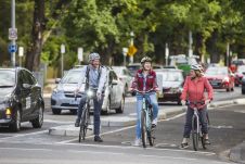
In urban planning, there is a case for stronger connections between global and local (‘glocal’) issues, strategies and actions. How can the Sustainable Development Goals (SDGs) help local governments to...

Intergeo 2021 is returning as a physical event and will be held in Hannover from 21-23 September. There is a comprehensive safety strategy in place based on COVID-19 prevention rules;...

The theme of this year’s Smart GEO Expo 2021 is ‘Digital Twin, Design the Smarter Future’. Asia’s biggest geospatial information technology exchange event is gearing up to take place from...

The Geospatial Information Roadshow 2021, hosted by the Ministry of Land, Infrastructure and Transport (MOLIT) of Korea and organized by Korea Land and Geospatial Informatix Corporation (LX), will open in...

Chima Iheaturu is the GIS and database manager for the Wildlife Conservation Society, Nigeria. He holds a bachelor’s degree in Surveying & Geoinformatics and an MSc in Geospatial & Mapping...
This site uses cookies. By continuing to use this website, you agree to our Cookies Policy. Agree