Making the Most of Smart Tools for Intelligent Results
Why do some organisations seem so much smarter than others? Why are some companies able to navigate the uncertain currents of the world around them and handle the inherent vagaries...

Why do some organisations seem so much smarter than others? Why are some companies able to navigate the uncertain currents of the world around them and handle the inherent vagaries...

Mapping the underground is one of the major challenges in creating an infrastructure map at the municipal, regional, and national level, which is a key foundation for a national digital...

The deployment of SAR in the space sector market has witnessed a tremendous increase lately, particularly due to the challenges in monitoring climate change and other environmental factors. Environmental remote...

As the world became captivated with the challenge of rescuing the 12 soccer boys and their coach from deep within the Tham Luang Nang Non cave system in Thailand, GIS...

Bruce Gittings runs the GIS programmes at the University of Edinburgh, having joined the staff there in 1987, with degrees in geology and GIS. He has interests in distributed and...

Alexander Avery is a recent graduate from the University of Edinburgh’s MSc course in GIS and has a BSc Hons in Geology and Petroleum Geology from the University of Aberdeen....
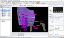
Hexagon‘s Mining division has introduced an improved mine planning solution called HxGN MinePlan 3D (formerly MineSight 3D), which now features full virtual reality, bringing a new dimension to visualising and...
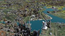
No modern city is future-proof without a ‘digital twin’: the 3D city model. 3D city models are virtual representations of urban environments and include buildings, terrain, infrastructure, landscapes, vegetation and...

The traditional way of mapping Earth’s geology and mineral resources is a costly and time-consuming undertaking. While satellites cannot entirely replace the expert in the field, they can certainly help...

This survey in southern France confirmed the suitability of UAV Lidar for mapping shoreline changes in the context of erosion and drinking water availability. The French Mediterranean coast is a...
This site uses cookies. By continuing to use this website, you agree to our Cookies Policy. Agree