Matt Lato
Matt Lato is a senior engineer and the innovation lead at BGC Engineering, Canada. His technical expertise is in the application of 3D remote sensing in geotechnical engineering. Matt is...
Matt Lato is a senior engineer and the innovation lead at BGC Engineering, Canada. His technical expertise is in the application of 3D remote sensing in geotechnical engineering. Matt is...

Charlene Ting is a chartered senior geologist in the London Geotechnics team. Charlene has developed expertise in a range of engineering geological and geotechnical projects in the UK, Middle East...

Ben Gilson is an associate in the London Geotechnics team and has worked on major linear infrastructure projects, alongside energy, residential and commercial projects since joining Arup in 2010. As...
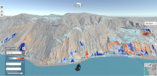
Lidar change detection (LCD) is one of the most capable techniques for mapping changing terrain through time. It can be applied in billion-dollar decisions to design, build and operate tunnels,...

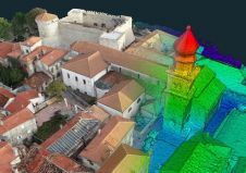
A 3D geological model has helped to save valuable time and millions of pounds for the Crossrail 2 railway project in London, UK, by identifying geological hazards along the route...

The concept of the digital twin has been gaining significant momentum in the geospatial domain since 2016. Although there is some consensus on the basic features of a digital twin,...
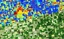
Emerging satellite data providers ConstellR and ScanWorld have announced a new partnership which aims to leverage combined Earth observation expertise to provide data-driven insights for agriculture and vegetation monitoring. The...

Tanya Slavova is currently working as a business analyst in Mapex JSC, as well as a chief assistant professor at the University of Mining and Geology in Sofia, Bulgaria. She...
3Dsurvey, a Slovenia-based image processing software manufacturer, is looking to expand its partner network with companies who want to support its mission to help surveyors all over the world work smarter,...

Bluesky International is co-funding research into the use of Lidar, machine learning and artificial intelligence to create citywide maps of trees enriched with new levels of information in an advanced postgraduate...
This site uses cookies. By continuing to use this website, you agree to our Cookies Policy. Agree