XEOS Imaging Inc.
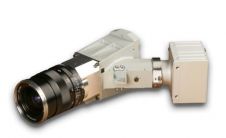
Specim, Spectral Imaging is launching a high-resolution hyperspectral imaging sensor with exceptional performance and the dimensions required for Unmanned Aerial Vehicles (UAV) and other challenging applications. The V10M sensor operates...

Trimble Access software for Spatial Imaging is an addition to Trimble's Connected Site solutions. Trimble Access is a streamlined field and office solution for surveyors and geospatial professionals that expedites...
Vexcel Imaging GmbH has selected Imagemaps as its sales representative responsible for the People's Republic of China, Taiwan, Australia, New Zealand and ASEAN (Singapore, Malaysia, Indonesia, Brunei, Thailand, Philippines, Vietnam,...

Vexcel Imaging is a global leader in aerial imaging, known for developing cutting-edge aerial cameras, mapping systems, and photogrammetric processing software. The UltraCam 4th generation system lineup includes the high-precision...
SPECIM have released AisaEAGLET, a Hyperspectral Imaging airborne sensor specifically designed for small aircrafts and Unmanned Aerial Vehicles (UAVs). AisaEAGLET will be officially presented at the EARSEL Imaging Spectroscopy workshop...
Geomatica 10.2, a complete set of geo-imaging software for remote sensing, digital photogrammetry, raster spatial analysis, map production, mosaicking and automated production workflows, provides new capabilities and extended functionality which...
Satellite imaging provider DMCii has announced that it will provide free DMC constellation satellite imagery for scientists to support global environmental monitoring projects. Scientists are invited to compete for the...
At the XXIst ISPRS Congress in Beijing, Vexcel Imaging -Microsoft's Photogrammetry division- has announced the UltraCamX Prime (UltraCamXp), an enhanced version of the widely used UltraCamX large format digital camera...
This site uses cookies. By continuing to use this website, you agree to our Cookies Policy. Agree