Cartomorphosis: an evolution that starts with cadastre
Over the past 15 years, geospatial information has enabled the transformation of towns, cities and a whole state in Mexico. The customer and data provider teamed up to create up-to-date...

Over the past 15 years, geospatial information has enabled the transformation of towns, cities and a whole state in Mexico. The customer and data provider teamed up to create up-to-date...
A topographic survey collects information about the land's natural and man-made characteristics, as well as its terrain. Buildings, fences, trees, and waterways are permanent structures that accurately define the ground and its boundaries. The elevation of the terrain is depicted by land contours and spot levels. Architects, engineers, construction builders, and others utilize topographic maps to precisely visualize their sites and speed up development. A topographic survey collects information about the land's natural and man-made characteristics, as well as its terrain. Buildings, fences, trees, and waterways are permanent structures that accurately define the ground...

Juan Partida is CFO of the government of Jalisco, having been a public servant for the last 15 years. From the outset, his involvements have included modernizing and designing cadastral...

The findings and recommendations of a new land administration report were recently reviewed and discussed in Tripoli, Libya, by government representatives, civil society, UN officials, private sector representatives and technical...
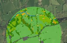
The UK’s Peak District National Park Authority is pioneering the use of artificial intelligence (AI) to automate the production of highly detailed land cover maps, in a project in partnership...

High-end technology-driven solutions often create serious implementation constraints in land administration. Furthermore, despite the developments and advances in geo-ICT, there is still a gap in the development of tools that...

Cadastre & Land Administration Geospatial data obviously is key to sustainable land management. But what are the common success factors for land administration and cadastral systems around the world? In this issue, we will...

Summer is on the way at long last and RICS Geomatics has been very busy on an ever-increasing UK and global portfolio. The early summer months see several of our...
This site uses cookies. By continuing to use this website, you agree to our Cookies Policy. Agree