UK Location Strategy Implementation
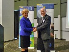
Ordnance Survey's GI strategist Keith Murray is being seconded to Defra (Department for Environment, Food and Rural Affairs) to help lead the UK's implementation of the UK Location Strategy (UKLS)...
Ordnance Survey's GI strategist Keith Murray is being seconded to Defra (Department for Environment, Food and Rural Affairs) to help lead the UK's implementation of the UK Location Strategy (UKLS)...
The 2007 Location Intelligence Conference, the premiere industry event focused on the use of location technology, has announced the agenda for this year’s conference. The conference will feature more than...
Blue Marble Geographic’s flagship software, Global Mapper Pro, is an all-in-one GIS package for analysing and processing vector, terrain, image and point cloud data. Compatible with over 380 different file...
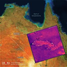
UP42 and OroraTech have signed a partnership agreement to grant easy and fast access to global high-resolution thermal-infrared imagery. UP42 is a geospatial developer platform and marketplace, and OroraTech is...
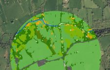
The UK’s Peak District National Park Authority is pioneering the use of artificial intelligence (AI) to automate the production of highly detailed land cover maps, in a project in partnership...

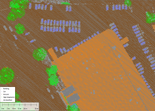
Both vertical and oblique aerial images have their own advantages, making them valuable in different reality mapping applications. So how can you choose between the two? This comparison will help...

In a high-flying endeavour spanning over six decades, the UK’s National Grid's fleet of advanced helicopters have been diligently patrolling pylons and power lines, ensuring the health and reliability of...
It can still be difficult to achieve centimetre-level accuracy in mobile mapping, especially in GNSS-denied or challenging areas such as in deep urban canyons, under foliage or through tunnels. However,...
The 9th General Assembly of EuroGeographics, the association for Europe's national mapping and cadastral agencies, took place in Vilnius, Lithuania. It was hosted by the National Land Service under the...
Vodafone will use Tele Atlas digital maps and location-based content across its global footprint for the company's location-based services (LBS) and navigation offerings, according to the agreement the companies have...
This site uses cookies. By continuing to use this website, you agree to our Cookies Policy. Agree