Mobile Geological Mapping Software
GAF has released a free trial version of GeoRover, a mobile geological mapping software, developed on the basis of experience gained from real geological mapping field work. The software integrates...
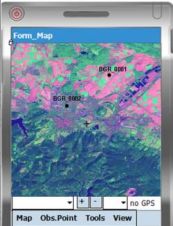
GAF has released a free trial version of GeoRover, a mobile geological mapping software, developed on the basis of experience gained from real geological mapping field work. The software integrates...
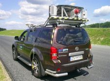
Gispro have successfully implemented Land Based Mobile Mapping System (MMS/MLS). The system consists of Riegl laser scanners, digital videoscanners and ground-penetrating radar. Positioning and orienation are established using POS420 and...
The use of Mobile Lidar systems enters the scene when large areas have to be surveyed at accuracy and resolution exceeding those available through aerial photogrammetry, and when using static...
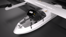
JOUAV has released the JoLiDAR-1000 Lidar sensor designed specifically for uncrewed aerial vehicles (UAVs or ‘drones’) as the latest addition to its array of high-performance Lidar sensors for use in...

Sven Cowan is NV5 Geospatial’s Programme Manager for Canada. He has over 20 years of experience in customer-facing positions within the geospatial information industry and has worked for multiple geospatial...

Visitor registration is now open for GEO Business, the UK's largest geospatial event. The free-to-attend expo, tailored for geospatial professionals seeking to harness the potential of location intelligence, will return...
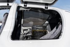
Diamond Aircraft and Vexcel Imaging have announced the next collaboration for a further expansion of Diamond’s special mission aircraft high-end sensor portfolio. The partnership will integrate the UltraCam Dragon 4.1...

A topobathymetric Lidar survey was conducted to support flood preparedness in Canada. Which techniques achieved exceptional precision, and what were the logistical challenges? Find out more in this article. As...
Large amounts of personal data, such as faces and number plates, are collected during mobile mapping. Receiving consent from individuals for large-scale data collection is not feasible but is required...

FARO has announced the acquisition of one the world's mobile scanning market leaders: GeoSLAM. With proprietary high-productivity simultaneous localization and mapping (SLAM) software to create 3D models for use in...
This site uses cookies. By continuing to use this website, you agree to our Cookies Policy. Agree