Monitoring 3D Urban Growth
This innovative approach to measuring 3D urban growth integrates Lidar processing with machine learning. It takes account of the specific needs of urban planners, is less complicated to run and...
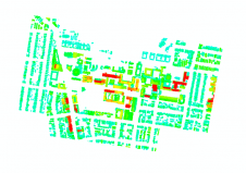
This innovative approach to measuring 3D urban growth integrates Lidar processing with machine learning. It takes account of the specific needs of urban planners, is less complicated to run and...
A group of Saudi Arabian and European partners have completed a project to implement and provide satellite based environmental information products and services to the Presidency of Meteorology and Environment...
Scientists from the USGS work with partners around the world to actively monitor the world’s volcanoes. They use seismometers to detect and monitor very small earthquakes that indicate that magma...
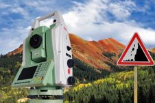
The Leica TM30 Sensor is designed for high-precision measurements and combines automatic, fast and silent operation to ensure that even the smallest movement in all monitoring applications is detected. The...
Rice is the most important staple grain in the world. Ninety per cent of rice plantations are distributed across Asia, providing daily food for 2.5 billion people in this region....
Rice is the most important staple grain in the world. Ninety per cent of rice plantations are distributed across Asia, providing daily food for 2.5 billion people in this region....
The mangroves of the Sunderban area in India are one of the most productive and diverse ecosystems in the world, and yet they are a threatened habitat. To formulate a...
GIS and GPS offer enormous potential to improve existing methods of biodiversity surveying and monitoring, supporting sampling design, data collection, visualisation, analysis and data management. The author describes experience gained...
Forest fires, illegal logging, rehabilitation of degraded land and watershed management are worldwide problems, monitoring being aided by modern technology including earth observation from space, image processing software, GIS and...
NASA scientists have developed a regional visualisation and monitoring system for Central America and the southern Mexican states designed to make NASA Earth observations and predictions freely and readily accessible...
This site uses cookies. By continuing to use this website, you agree to our Cookies Policy. Agree