NASA Monitoring System
NASA scientists have developed a regional visualisation and monitoring system for Central America and the southern Mexican states designed to make NASA Earth observations and predictions freely and readily accessible...
NASA scientists have developed a regional visualisation and monitoring system for Central America and the southern Mexican states designed to make NASA Earth observations and predictions freely and readily accessible...
Space-based imagery is being used to assess disaster areas and direct relief efforts in areas hit by the tsunamis on 26th December 2004. Canada's RADARSAT-1 satellite previously acquired over 70...

It is important to keep a watchful eye on glacial melt to avoid the sudden collapse of glaciers leading to tragedy, such as happened at the Marmolada glacier in the...

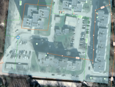
NV5 Geospatial has announced the debut of the ARIS II Rover, its upgraded robotic electric substation monitoring system. After five years of in-field implementation and testing, the rover meets the...
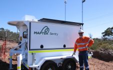
Maptek has announced it will be displaying its latest mobile monitoring system at Slope Stability 2018. “At its heart, the conference is tackling an issue, slope stability, which has a...
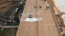
Trimble has introduced data integrity monitoring for its precise point positioning (PPP) correction service, CenterPoint RTX Fast. The Trimble RTX Integrity monitoring system is an innovative, patented solution, built in...
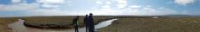
Coastal and estuarine saltmarsh has long been recognised as having key physical, ecological, and recreational value, acting as sediment and nutrient traps and as natural coastal protection structures functioning as...

In this case study, QuestUAV describes the use of UAV photography and photogrammetry to measure long-term erosion of the coast of northeast England. The British Geological Survey states that across...

Automated movement detection supports informed decisions about infrastructure, including for waterways as illustrated by this project in the Netherlands. Following storm-related damage to a weir on the River Maas, Trimble...
Real-time monitoring can reduce long-term losses caused by holes across a network of water pipes. At 6 bar pressure, a pipe with a 6mm hole will leak 1.8 cubic metres...
This site uses cookies. By continuing to use this website, you agree to our Cookies Policy. Agree