RIEGL Launches iPad Point Cloud Viewer
RIEGL has introduced an app, called RiALITY, for Lidar data visualisation. The app allows users to experience Lidar data in a completely new environment and also allows easier Lidar data...

RIEGL has introduced an app, called RiALITY, for Lidar data visualisation. The app allows users to experience Lidar data in a completely new environment and also allows easier Lidar data...

Why base the terrain model in infrastructure projects on 'old' contour maps when you can get a fresh and more accurate representation of the terrain based on laser scanning? That's...
Gexcel (Italy) is launching a new point cloud streaming service based on a web application. It will launch this application during Intergeo, to be held from 8 to 10 October...
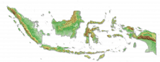
Intermap has won a US$20 million contract to map the Indonesian island of Sulawesi this year. The contract is the first phase of the Indonesian national topographic basemap programme to...

There are indications that today’s technological advances are putting a fully operational multipurpose cadastre within reach, following decades of a global vision and small-scale progress towards a comprehensive map-centric land...
Topcon Positioning Systems (TPS) new ScanMaster version 1.5 software is designed to simplify laser scanner point collection and manipulation. ScanMaster software is used with Topcon's GLS-1000 scanner, a compact and...
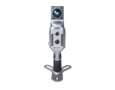
Stonex has launched a new SLAM solution for fast and efficient large-area surveys: the X70GO SLAM laser scanner. It combines mobile scanning with a stationary mode to scan with higher...

For consistent and precise digital GIS and photogrammetry workflows, raw data must first be converted into integrable and thus valuable information components that meet the requirements of the respective application...
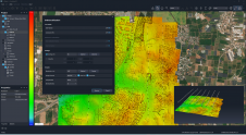
SimActive has announced the release of Correlator3D Version 10. This latest version comes with a completely redesigned user interface, featuring a new dark mode option, and also allows for point...

YellowScan recently launched its software add-on module: Colorization. This third software module enhances the capability of CloudStation, YellowScan’s powerful data processing tool that provides users the ability to create and...
This site uses cookies. By continuing to use this website, you agree to our Cookies Policy. Agree