Insight into Point Cloud Software
To be useful, the millions or even billions of 3D points generated by a variety of active and passive sensors need to be stored, organised, combined, georeferenced, measured and analysed,...

To be useful, the millions or even billions of 3D points generated by a variety of active and passive sensors need to be stored, organised, combined, georeferenced, measured and analysed,...
The Point Cloud CAD 2010 is Microsurvey's latest product that allows the individual to work with Point Cloud and LIDAR data with ease. MicroSurvey has spent the last year working...
Point clouds are increasingly beginning to prove their worth in the construction industry, but the ability to work with point clouds within AutoCAD has been limited. Pointools Model makes it...
Virtualgeo was established in 1994 as a spin-off from an established survey company active in the field of topographic survey and infrastructure planning since 1985. Virtualgeo has three offices in...
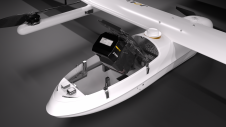
JOUAV has released the JoLiDAR-1000 Lidar sensor designed specifically for uncrewed aerial vehicles (UAVs or ‘drones’) as the latest addition to its array of high-performance Lidar sensors for use in...

Visitor registration is now open for GEO Business, the UK's largest geospatial event. The free-to-attend expo, tailored for geospatial professionals seeking to harness the potential of location intelligence, will return...

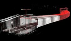
A topobathymetric Lidar survey was conducted to support flood preparedness in Canada. Which techniques achieved exceptional precision, and what were the logistical challenges? Find out more in this article. As...

Sven Cowan is NV5 Geospatial’s Programme Manager for Canada. He has over 20 years of experience in customer-facing positions within the geospatial information industry and has worked for multiple geospatial...
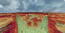
A dense annotated ground-truth Lidar dataset of the city of Dublin is the first of its kind regarding the accuracy, density and diversity of classes. The hierarchical labels offer excellent...
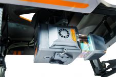
The AlphaUni 20 (AU20) Lidar system represents a new era in cost-effective, multi-platform mobile mapping solutions, according to CHC Navigation (CHCNav), a global leader in precision mapping, positioning and navigation...
This site uses cookies. By continuing to use this website, you agree to our Cookies Policy. Agree